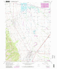
1962 Map of Wellsville
USGS Topo · Published 1986About this map
The Cache Valley floor meets the steep slopes of the Wasatch Cache National Forest in this topographic survey, which highlights the sophisticated water management systems essential to northern Utah's agriculture. The Little Bear River winds through the center of the sheet, feeding into the Hyrum Reservoir State Recreation Area at the southeastern corner. Critical irrigation infrastructure is meticulously charted, including the Wellsville Mendon Upper Canal and the Wellsville Mendon Lower Canal, which follow the contours of the benchland to support the settlements of Wellsville and Mendon.
Find a feature on this map
42 named features on this map. Tap any name to fly to it.
Don’t see what you’re looking for? This feature index may not catch every label — zoom into the map to look around manually.
Map Details
Editions of this 1962 Wellsville Map
3 editions found
Other maps of this area

1914 · Logan
USGS Topo · 1:125,000

1916 · Logan
USGS Topo · 1:125,000

1954 · Ogden
USGS Topo · 1:250,000

1954 · Brigham City
USGS Topo · 1:250,000

1955 · Paradise
USGS Topo · 1:24,000

1955 · Mount Pisgah
USGS Topo · 1:24,000

1955 · Brigham City
USGS Topo · 1:24,000

1958 · Ogden
USGS Topo · 1:250,000

1958 · Brigham City
USGS Topo · 1:250,000

1960 · Ogden
USGS Topo · 1:250,000