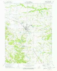
1973 Map of Wellsville
USGS Topo · Published 1975About this map
Wellsville serves as a central hub for agricultural and rail activity in this 1970s survey of the Upper Loutre region. The landscape is defined by the convergence of the Burlington Northern and Norfolk and Western railroads, with an Old Railroad Grade further marking the evolution of transportation in the county. Significant natural and recreational areas are present, including the Marshall I Diggs State Wildlife Management Area and the Wellsville Lake State Wildlife Management Area surrounding Wellsville Lake.
Find a feature on this map
28 named features on this map. Tap any name to fly to it.
Don’t see what you’re looking for? This feature index may not catch every label — zoom into the map to look around manually.
Map Details
Editions of this 1973 Wellsville Map
2 editions found
Other maps of this area

1890 · Louisiana
USGS Topo · 1:125,000

1890 · Mexico
USGS Topo · 1:125,000

1890 · Hermann
USGS Topo · 1:125,000

1890 · Fulton
USGS Topo · 1:125,000

1940 · Montgomery City
USGS Topo · 1:62,500

1942 · Montgomery City
USGS Topo · 1:62,500

1942 · Wellsville
USGS Topo · 1:62,500

1942 · New Florence
USGS Topo · 1:62,500

1942 · Bellflower
USGS Topo · 1:62,500

1945 · Bellflower
USGS Topo · 1:62,500