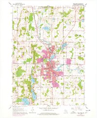
1959 Map of West Bend
USGS Topo · Published 1977About this map
The Milwaukee River carves a path through the heart of this landscape, anchoring the industrial and residential growth of West Bend and the northern village of Barton. During the mid-twentieth century, this region experienced significant expansion, as evidenced by the purple revisions indicating new suburban development near Young America and the West Bend Municipal Airport. The infrastructure of education and faith is dense here, with institutions like Holy Angels Sch and St Marys Sch serving the local population.
Find a feature on this map
56 named features on this map. Tap any name to fly to it.
Don’t see what you’re looking for? This feature index may not catch every label — zoom into the map to look around manually.
Map Details
Editions of this 1959 West Bend Map
4 editions found

Other maps of this area

1904 · West Bend
USGS Topo · 1:62,500

1904 · Hartford
USGS Topo · 1:62,500

1955 · Campbellsport
USGS Topo · 1:62,500

1955 · Kewaskum
USGS Topo · 1:62,500

1957 · Madison
USGS Topo · 1:250,000

1959 · West Bend
USGS Topo · 1:62,500

1959 · Hartford
USGS Topo · 1:62,500

1959 · Allenton
USGS Topo · 1:24,000

1959 · Newburg
USGS Topo · 1:24,000
1959 · Jackson
USGS Topo · 1:24,000