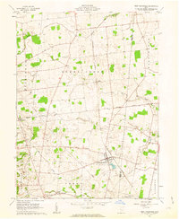
1961 Map of West Mansfield
USGS Topo · Published 1963About this map
West Mansfield serves as the primary hub of this 1961 survey, situated at the junction of the New York Central railroad and a network of rural roads. The landscape is defined by the headwaters of several drainages, including Rush Creek, Bokes Creek, and Mill Creek, which wind through a mosaic of agricultural fields and small woodlots. One of the most distinctive historical artifacts shown is the Treaty Line, a significant surveying boundary that cuts diagonally across the township lines of Bokes Creek and York. Genealogists will find a high density of small burial grounds scattered across the countryside, such as Hathaway Cem, Early Cem, and Southard Cem. Small rural clusters like Walnut Grove and North Greenfield anchor the surrounding townships of Jefferson and Perry, reflecting the dispersed settlement patterns of Logan and Union Counties during this era.
Find a feature on this map
27 named features on this map. Tap any name to fly to it.
Don’t see what you’re looking for? This feature index may not catch every label — zoom into the map to look around manually.
Map Details
Editions of this 1961 West Mansfield Map
Other maps of this area

1913 · East Liberty
USGS Topo · 1:62,500

1913 · Richwood
USGS Topo · 1:62,500

1915 · Richwood
USGS Topo · 1:62,500

1915 · East Liberty
USGS Topo · 1:62,500

1915 · Kenton
USGS Topo · 1:62,500

1915 · La Rue
USGS Topo · 1:62,500

1944 · East Liberty
USGS Topo · 1:62,500

1944 · Kenton
USGS Topo · 1:62,500

1944 · Richwood
USGS Topo · 1:62,500

1950 · Marion
USGS Topo · 1:250,000
Featured Places
- West Mansfield, OH
- Rushcreek Township, OH
- Jefferson Township, OH
- Perry Township, OH
- Liberty Township, OH