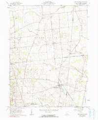
1961 Map of West Mansfield
USGS Topo · Published 1991About this map
The Greenville Treaty Line bisects this agricultural landscape in the 1960s, marking a significant historical boundary that continues to influence local property lines and roads. Centered on West Mansfield, the map details a region where the New York Central railroad serves as a primary transit corridor, connecting small settlements like Horton and Walnut Grove. The terrain is defined by the drainage of Bokes Creek and Rush Creek, with the Virginia Military District's irregular land patterns evident in the southern sections. Genealogists will find a high density of small family and community burial sites, including Quaker Cem, Early Cem, and Hathaway Cem, alongside rural landmarks such as Bethel Ch and the recreational grounds of Camp Macochee.
Find a feature on this map
27 named features on this map. Tap any name to fly to it.
Don’t see what you’re looking for? This feature index may not catch every label — zoom into the map to look around manually.
Map Details
Editions of this 1961 West Mansfield Map
Other maps of this area

1913 · East Liberty
USGS Topo · 1:62,500

1913 · Richwood
USGS Topo · 1:62,500

1915 · Richwood
USGS Topo · 1:62,500

1915 · East Liberty
USGS Topo · 1:62,500

1915 · Kenton
USGS Topo · 1:62,500

1915 · La Rue
USGS Topo · 1:62,500

1944 · East Liberty
USGS Topo · 1:62,500

1944 · Kenton
USGS Topo · 1:62,500

1944 · Richwood
USGS Topo · 1:62,500

1950 · Marion
USGS Topo · 1:250,000
Featured Places
- West Mansfield, OH
- Rushcreek Township, OH
- Jefferson Township, OH
- Perry Township, OH
- Liberty Township, OH