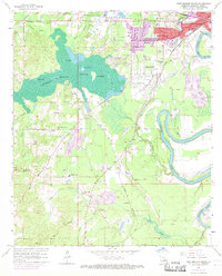
1957 Map of West Monroe South
USGS Topo · Published 1969About this map
Cheniere Brake dominates the western half of this map, a labyrinth of cypress swamps and open water including Pucketts Lake and Little Lake. This hydrological network defines the local geography, with named landmasses like Pine Island and Joes Island rising above the swamp floor. To the east, the urban expansion of West Monroe and Brownville is visible in purple revision tinting, showing the mid-century growth toward the Ouachita River. Rural life is anchored by a network of local institutions, including Woodlawn Sch and Pleasant Hill Ch further south. The Illinois Central railroad cuts through the terrain, connecting the industrial outskirts of Bawcomville with smaller landings and settlements like Summit and Lapine. Genealogists will find value in the specific placement of the Old Sardis Cem and New Sardis Cem near Rawls Branch.
Find a feature on this map
48 named features on this map. Tap any name to fly to it.
Don’t see what you’re looking for? This feature index may not catch every label — zoom into the map to look around manually.
Map Details
Editions of this 1957 West Monroe South Map
4 editions found
Other maps of this area

1935 · Drew
USGS Topo · 1:62,500

1940 · Monroe
USGS Topo · 1:62,500

1952 · Calhoun
USGS Topo · 1:62,500

1953 · Chatham
USGS Topo · 1:62,500

1955 · Shreveport
USGS Topo · 1:250,000

1956 · Shreveport
USGS Topo · 1:250,000

1957 · Monroe North
USGS Topo · 1:62,500

1957 · West Monroe North
USGS Topo · 1:24,000

1957 · West Monroe South
USGS Topo · 1:24,000

1957 · Monroe South
USGS Topo · 1:24,000