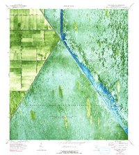
1974 Map of West Of Big Lake
USGS Topo · Published 1993About this map
The Hillsboro Canal cuts a sharp diagonal through this landscape, serving as a critical boundary in the managed hydrology of the northern Everglades during the mid-1970s. This orthophotomap reveals the stark transition between the rectangular agricultural plots to the northwest and the expansive wetlands of the Loxahatchee National Wildlife Refuge and Everglades Wildlife Management Area. The region is defined by a massive infrastructure of water control, including Levee 39 and Levee 6, which isolate specific conservation zones where water is impounded periodically. Evidence of human activity in the marsh is minimal, restricted to a few utility markers like Pumping Sta No 2 and an Airboat Trail winding through the vegetation. The map illustrates the complex division of the Florida interior into designated management units, including the W Browns Farm Wildlife Management Area, highlighting the mid-century effort to balance agricultural drainage with wildlife preservation.
Find a feature on this map
13 named features on this map. Tap any name to fly to it.
Don’t see what you’re looking for? This feature index may not catch every label — zoom into the map to look around manually.
Map Details
Editions of this 1974 West Of Big Lake Map
3 editions found

Other maps of this area

1956 · West Palm Beach
USGS Topo · 1:250,000

1957 · West Palm Beach
USGS Topo · 1:250,000

1958 · West Palm Beach
USGS Topo · 1:250,000

1963 · Fort Lauderdale 2 SE
USGS Topo · 1:24,000
1970 · Loxahatchee SE
USGS Topo · 1:24,000

1970 · Loxahatchee SW
USGS Topo · 1:24,000

1970 · Shawano
USGS Topo · 1:24,000

1973 · Fort Lauderdale 2 NE
USGS Topo · 1:24,000

1973 · Fort Lauderdale 2 SW
USGS Topo · 1:24,000

1974 · Everglades 1 SE
USGS Topo · 1:24,000