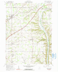
1961 Map of West Salem
USGS Topo · Published 1991About this map
The boundary between the South Boundary Congress Lands and the Connecticut Western Reserve cuts through this rural landscape during the early 1960s. The village of West Salem serves as a local hub along the Erie-Lackawanna railroad, while Burbank and Aukerman sit further east along the Baltimore and Ohio line. The terrain is marked by the winding courses of Killbuck Creek and Muddy Fork, with historical landmarks such as the Indian Mounds near Shade Creek indicating ancient land use.
Find a feature on this map
43 named features on this map. Tap any name to fly to it.
Don’t see what you’re looking for? This feature index may not catch every label — zoom into the map to look around manually.
Map Details
Editions of this 1961 West Salem Map
2 editions found
Other maps of this area

1901 · Wooster
USGS Topo · 1:62,500

1903 · Wooster
USGS Topo · 1:62,500

1904 · Medina
USGS Topo · 1:62,500

1904 · Wellington
USGS Topo · 1:62,500

1906 · Medina
USGS Topo · 1:62,500

1906 · Wellington
USGS Topo · 1:62,500

1906 · West Salem
USGS Topo · 1:62,500

1908 · West Salem
USGS Topo · 1:62,500

1950 · Cleveland
USGS Topo · 1:250,000

1950 · Marion
USGS Topo · 1:250,000