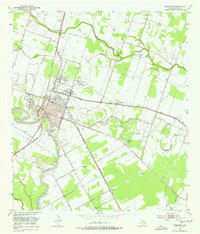
1953 Map of Wharton
USGS Topo · Published 1977About this map
The Colorado River carves a winding path through the heart of Wharton, defining a landscape where river navigation once gave way to a dense network of iron rails. By the mid-1950s, the town served as a significant transportation hub, evidenced by the crossing of the Southern Pacific and the Gulf Colorado and Santa Fe (AT&SF) railroads. Educational and civic growth is anchored by Wharton Junior College and the County Fairgrounds, while the rural outskirts are dotted with smaller communities like Dinsmore and Lefman. Oxbow formations and abandoned channels have left distinctive water bodies such as Halfmoon Lake and Manso Lake scattered across the floodplain. Local spiritual life is visible at New Zion Bethel Ch and Little Zion Ch, along with the associated Little Zion Cem, providing specific points of interest for genealogists tracing family roots in this corner of the Texas coastal plain.
Find a feature on this map
26 named features on this map. Tap any name to fly to it.
Don’t see what you’re looking for? This feature index may not catch every label — zoom into the map to look around manually.
Map Details
Editions of this 1953 Wharton Map
4 editions found
Other maps of this area

1950 · Houston
USGS Topo · 1:250,000

1952 · Pledger
USGS Topo · 1:24,000

1952 · Lane City
USGS Topo · 1:24,000

1952 · Pierce
USGS Topo · 1:24,000

1952 · Egypt
USGS Topo · 1:24,000

1953 · Kendleton
USGS Topo · 1:24,000

1953 · Wharton
USGS Topo · 1:24,000

1953 · Hungerford
USGS Topo · 1:24,000

1953 · Glen Flora
USGS Topo · 1:24,000

1953 · Boling
USGS Topo · 1:24,000