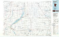
1985 Map of Wheaton
USGS Topo · Published 1985About this map
Lake Traverse and the narrow Big Stone Lake dominate this tri-state borderland where Minnesota, North Dakota, and South Dakota converge. The 1985 survey captures the landscape as a grid of agriculture and conservation, marked by numerous protected areas like the National Waterfowl Production Area and the Mallard Hole State Wildlife Management Area. The Burlington Northern railroad serves as the primary industrial spine, connecting prairie settlements such as Wheaton, Graceville, and Herman.
Find a feature on this map
98 named features on this map. Tap any name to fly to it.
Don’t see what you’re looking for? This feature index may not catch every label — zoom into the map to look around manually.
Map Details
Editions of this 1985 Wheaton Map
2 editions found
Other maps of this area

1904 · Wahpeton
USGS Topo · 1:125,000

1907 · Wyndmere
USGS Topo · 1:125,000

1910 · Wendell
USGS Topo · 1:62,500

1910 · Chokio
USGS Topo · 1:62,500

1911 · Barrett
USGS Topo · 1:62,500

1911 · Herman
USGS Topo · 1:62,500

1912 · Chokio
USGS Topo · 1:62,500

1912 · Morris
USGS Topo · 1:62,500

1913 · Ashby
USGS Topo · 1:62,500

1913 · Wendell
USGS Topo · 1:62,500