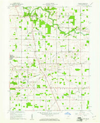
1960 Map of Wheeling
USGS Topo · Published 1976About this map
Mississinewa River meanders across the northern portion of this landscape, flanked by numerous small tributaries like Austin Run and Ford Run that drain the surrounding agricultural fields. The area is defined by a rigid grid of country roads, including Van Devender Road and Pennsylvania Road, which connect rural settlements and isolated farmsteads. Significant for local history and genealogy, several country churches and cemeteries are recorded, such as Mt Zion Ch and the Wheeling Cem. The Chesapeake and Ohio railroad cuts diagonally across the central terrain, passing through the small community of Stockport and near Anthony. This network of rail and road illustrates the mid-century infrastructure of Delaware County, Indiana, prior to later modernization. Further south, drainage features like Killbuck Creek and Mud Creek intersect the township lines, while Olive Chapel and Corinth Ch serve as local landmarks for the surrounding rural population.
Find a feature on this map
52 named features on this map. Tap any name to fly to it.
Don’t see what you’re looking for? This feature index may not catch every label — zoom into the map to look around manually.
Map Details
Editions of this 1960 Wheeling Map
4 editions found
Other maps of this area

1952 · Muncie East
USGS Topo · 1:24,000

1952 · Muncie West
USGS Topo · 1:24,000

1953 · Muncie
USGS Topo · 1:250,000

1956 · Muncie
USGS Topo · 1:250,000

1960 · Gilman
USGS Topo · 1:24,000

1960 · Hartford City East
USGS Topo · 1:24,000

1960 · Eaton
USGS Topo · 1:24,000

1960 · Wheeling
USGS Topo · 1:24,000

1960 · Gas City
USGS Topo · 1:24,000

1960 · Gaston
USGS Topo · 1:24,000