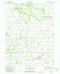
1960 Map of Wheeling
USGS Topo · Published 1982About this map
The Mississinewa River winds through the northern portion of this Delaware County landscape, defining the rural character of northern Indiana at the dawn of the 1960s. Small agricultural hubs like Wheeling and Gaston anchor a grid of country lanes such as Hedgeland Road and Studebaker Road. The Chesapeake and Ohio railroad cuts diagonally across the southern townships, passing near Anthony and the waters of Killbuck Creek. Local genealogy and community history are well-preserved through several rural congregations and burial grounds, including Olive Chapel, Corinth Ch, and the Wheeling Cem. The map provides a look at the mid-century infrastructure of the region, noting numerous Gas Wells that reflect the area's geological and industrial utility.
Find a feature on this map
23 named features on this map. Tap any name to fly to it.
Don’t see what you’re looking for? This feature index may not catch every label — zoom into the map to look around manually.
Map Details
Editions of this 1960 Wheeling Map
4 editions found
Other maps of this area

1952 · Muncie East
USGS Topo · 1:24,000

1952 · Muncie West
USGS Topo · 1:24,000

1953 · Muncie
USGS Topo · 1:250,000

1956 · Muncie
USGS Topo · 1:250,000

1960 · Gilman
USGS Topo · 1:24,000

1960 · Hartford City East
USGS Topo · 1:24,000

1960 · Eaton
USGS Topo · 1:24,000

1960 · Wheeling
USGS Topo · 1:24,000

1960 · Gas City
USGS Topo · 1:24,000

1960 · Gaston
USGS Topo · 1:24,000