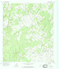
1962 Map of Wheelock
USGS Topo · Published 1985About this map
Wheelock and the surrounding ranchlands of Robertson County appear here during a period of quiet rural stability in the early 1960s. The landscape is defined by a dense network of watercourses, including Copperas Creek and the long drainages of Cedar Hollow and Wolf Hollow, which cut through the wooded terrain. This era preserves several local landmarks of genealogical importance, such as Henry Prairie Ch and its associated Henry Prairie Road.
Find a feature on this map
35 named features on this map. Tap any name to fly to it.
Don’t see what you’re looking for? This feature index may not catch every label — zoom into the map to look around manually.
Map Details
Editions of this 1962 Wheelock Map
Other maps of this area

1925 · Marquez No. 4
USGS Topo · 1:48,000

1927 · Marquez
USGS Topo · 1:62,500

1930 · Marquez
USGS Topo · 1:62,500

1954 · Waco
USGS Topo · 1:250,000

1954 · Austin
USGS Topo · 1:250,000

1955 · Waco
USGS Topo · 1:250,000

1961 · Hearne North
USGS Topo · 1:24,000

1961 · Hearne South
USGS Topo · 1:24,000

1962 · Edge
USGS Topo · 1:24,000

1962 · Wheelock
USGS Topo · 1:24,000