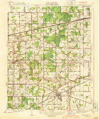
1940 Map of Whitehouse
USGS Topo · Published 1940About this map
The village of Whitehouse serves as the focal point of this 1930s landscape, positioned at a critical junction of the Wabash railroad and numerous local routes like Waterville Road. The surrounding territory in Lucas County is defined by an intensive network of drainage systems, including Swan Creek, Mosquito Creek, and dozens of named features like Soul Ditch and Bovee Ditch, which reveal the engineered nature of the regional agricultural economy. Evidence of early 20th-century aviation infrastructure appears with the Airway Beacon located near the Metropolitan Park. Genealogists and local historians can locate long-standing community landmarks such as Roberts Chapel, Whitehouse Cem, and several rural schoolhouses like Wilkins Sch and Bush Sch. The map also captures the path of the Toledo New York and Central Indiana railroad as it cuts through the townships of Springfield and Swanton.
Find a feature on this map
78 named features on this map. Tap any name to fly to it.
Don’t see what you’re looking for? This feature index may not catch every label — zoom into the map to look around manually.
Map Details
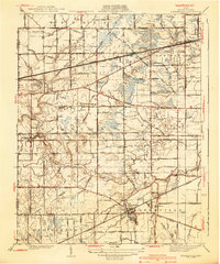
Editions of this 1940 Whitehouse Map
2 editions found
Other maps of this area

1900 · Toledo
USGS Topo · 1:62,500

1901 · Bowling Green
USGS Topo · 1:62,500

1903 · Bowling Green
USGS Topo · 1:62,500

1909 · Mc Clure
USGS Topo · 1:62,500

1911 · Swanton
USGS Topo · 1:62,500

1914 · Swanton
USGS Topo · 1:62,500

1935 · Grand Rapids
USGS Topo · 1:24,000

1935 · Whitehouse
USGS Topo · 1:24,000

1935 · Maumee
USGS Topo · 1:24,000

1935 · Berkey
USGS Topo · 1:24,000