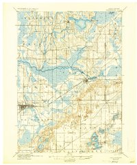
1924 Map of Whitewater
USGS Topo · Published 1937About this map
Whitewater serves as the primary regional hub in this early twentieth-century survey, its street grid and industrial footprint defined by the Chicago Milwaukee and St. Paul railroad corridor. The landscape is characterized by a high density of wetlands and glacial lakes, including the expansive Lauderdale Lakes and Whitewater Lake in the southern reaches. Numerous small settlements such as Hebron, Rome, and Little Prairie are connected by a network of rural roads, indicating a well-established agricultural economy focused on the fertile prairies. The presence of Heaths Mills on the Bark River highlights the early reliance on water power for local industry. The map reveals the intricate drainage patterns of the Scuppernong River basin and the varying elevations of the Lagrange moraine, providing a clear record of the area's physical and social geography before mid-century modernizations changed the rural character of Walworth and Jefferson counties.
Find a feature on this map
35 named features on this map. Tap any name to fly to it.
Don’t see what you’re looking for? This feature index may not catch every label — zoom into the map to look around manually.
Map Details
Editions of this 1924 Whitewater Map
4 editions found

Other maps of this area

1891 · Waterloo
USGS Topo · 1:62,500

1891 · Koshkonong
USGS Topo · 1:62,500

1892 · Watertown
USGS Topo · 1:62,500

1892 · Oconomowoc
USGS Topo · 1:62,500

1892 · Whitewater
USGS Topo · 1:62,500

1892 · Eagle
USGS Topo · 1:62,500

1893 · Delavan
USGS Topo · 1:62,500

1893 · Whitewater
USGS Topo · 1:62,500

1893 · Shopiere
USGS Topo · 1:62,500

1893 · Geneva
USGS Topo · 1:62,500