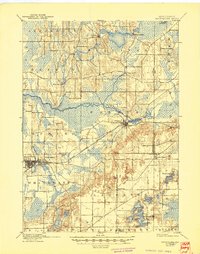
1924 Map of Whitewater
USGS Topo · Published 1944About this map
The Chicago Milwaukee and St Paul railroad cuts a diagonal line through the glaciated landscapes of Jefferson, Walworth, and Waukesha Counties, connecting the prominent settlement of Whitewater to Palmyra. The map reveals a post-frontier Wisconsin characterized by scattered prairie settlements and a dense network of water features. To the north, the Bark River and Scuppernong River wind through low-lying marshlands and small hamlets like Rome and Hebron. In the south, the terrain becomes increasingly kettle-pocked, featuring numerous water bodies such as Whitewater Lake and the clustered Lauderdale Lakes. This 1924 edition, based on earlier surveys by H.L. McDonald and Van. H. Manning Jr., documents a landscape of agrarian transitions, where small mill sites like Heaths Mills remained distinct markers of local industry before the widespread consolidation of the modern era.
Find a feature on this map
33 named features on this map. Tap any name to fly to it.
Don’t see what you’re looking for? This feature index may not catch every label — zoom into the map to look around manually.
Map Details
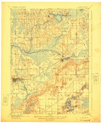
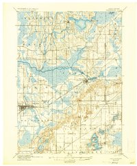
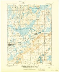
Editions of this 1924 Whitewater Map
4 editions found
Other maps of this area

1891 · Waterloo
USGS Topo · 1:62,500

1891 · Koshkonong
USGS Topo · 1:62,500

1892 · Watertown
USGS Topo · 1:62,500

1892 · Oconomowoc
USGS Topo · 1:62,500

1892 · Whitewater
USGS Topo · 1:62,500

1892 · Eagle
USGS Topo · 1:62,500

1893 · Delavan
USGS Topo · 1:62,500

1893 · Whitewater
USGS Topo · 1:62,500

1893 · Shopiere
USGS Topo · 1:62,500

1893 · Geneva
USGS Topo · 1:62,500