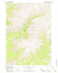
1969 Map of Wiggins Peak
USGS Topo · Published 1979About this map
The Absaroka Range dominates this late-1960s survey of Fremont County, where high-elevation summits and steep drainage systems define the landscape within the Shoshone National Forest. High points like Wiggins Peak and Mount Kent anchor a terrain carved by deep incisions such as Brown Rock Canyon and Black Canyon. The map reveals a wild, roadless interior where movement is dictated by the flow of water and established paths, including the Wiggins Fork Trail and the Emerald Creek Trail. The prominence of named water bodies like Caldwell Creek, Blue Creek, and the Wiggins Fork reflects the importance of these riparian corridors for navigation through the mountainous forest. For the researcher, this sheet preserves the primitive state of the region's wilderness, marking essential crossings like Bear Creek Pass and various segments of unnamed Pack Trail routes used before more modern infrastructure reached this part of Wyoming.
Find a feature on this map
17 named features on this map. Tap any name to fly to it.
Don’t see what you’re looking for? This feature index may not catch every label — zoom into the map to look around manually.
Map Details
Editions of this 1969 Wiggins Peak Map
2 editions found
Other maps of this area

1904 · Kirwin
USGS Topo · 1:125,000

1905 · Younts Peak
USGS Topo · 1:125,000

1906 · Kirwin
USGS Topo · 1:125,000

1907 · Younts Peak
USGS Topo · 1:125,000

1955 · Thermopolis
USGS Topo · 1:250,000

1956 · Indian Point
USGS Topo · 1:24,000

1956 · Snow Lake
USGS Topo · 1:24,000

1956 · Emerald Lake
USGS Topo · 1:24,000

1958 · Thermopolis
USGS Topo · 1:250,000

1962 · Thermopolis
USGS Topo · 1:250,000