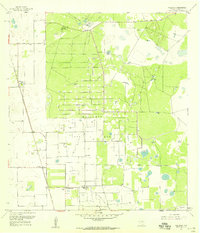
1956 Map of Willamar
USGS Topo · Published 1958About this map
Willamar Oil Field dominates this South Texas landscape, defined by a dense network of pipelines and pumping stations established during the mid-century petroleum boom. The settlement patterns reflect the region's dual identity as both energy hub and cattle country, with industrial sites like Willamar Camp situated near traditional landholdings such as El Sauz Ranch and La Jarita Ranch. The transition from rail to road is evident along the Old Railroad Grade running north to south through the community of Willamar. To the south, the North Floodway and drainage infrastructure like the East Main Drain speak to the complex water management required in Willacy County. Scattered across the brush and field are several family or community burial grounds, including El Toro Cem and La Jarita Cem, offering critical touchpoints for genealogical research in this part of the Rio Grande Valley.
Find a feature on this map
31 named features on this map. Tap any name to fly to it.
Don’t see what you’re looking for? This feature index may not catch every label — zoom into the map to look around manually.
Map Details
Editions of this 1956 Willamar Map
3 editions found
Other maps of this area

1921 · Tarida Ranch
USGS Topo · 1:62,500

1930 · La Leona
USGS Topo · 1:24,000

1932 · Combes
USGS Topo · 1:31,680

1933 · Paso Real
USGS Topo · 1:31,680

1936 · La Leona
USGS Topo · 1:31,680

1952 · Hawk Island
USGS Topo · 1:24,000

1952 · Port Mansfield
USGS Topo · 1:24,000

1952 · South of Potrero Lopeno
USGS Topo · 1:62,500

1953 · Brownsville
USGS Topo · 1:250,000
1955 · La Leona
USGS Topo · 1:62,500