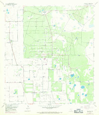
1956 Map of Willamar
USGS Topo · Published 1971About this map
Willamar Oil Field dominates this South Texas landscape, defined by a dense grid of production infrastructure including a Pumping Sta and a complex network of pipelines. The region’s ranching roots remain visible through established family-named holdings like El Sauz Ranch and La Jarita Ranch, which sit alongside the industrial expansion of the mid-20th century. Water management is a primary feature of the terrain, with the East Main Drain and the North Floodway cutting through the brush country to control the coastal plains. Small settlements and industrial outposts such as Willamar and Willamar Camp serve as the focal points for local history researchers and genealogists, who may also find interest in the El Toro Cem and La Jarita Cem located near the ranches.
Find a feature on this map
29 named features on this map. Tap any name to fly to it.
Don’t see what you’re looking for? This feature index may not catch every label — zoom into the map to look around manually.
Map Details
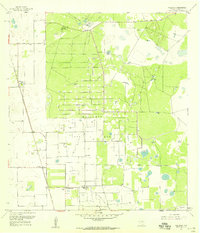
Editions of this 1956 Willamar Map
3 editions found
Other maps of this area

1921 · Tarida Ranch
USGS Topo · 1:62,500

1930 · La Leona
USGS Topo · 1:24,000

1932 · Combes
USGS Topo · 1:31,680

1933 · Paso Real
USGS Topo · 1:31,680

1936 · La Leona
USGS Topo · 1:31,680

1952 · Hawk Island
USGS Topo · 1:24,000

1952 · Port Mansfield
USGS Topo · 1:24,000

1952 · South of Potrero Lopeno
USGS Topo · 1:62,500

1953 · Brownsville
USGS Topo · 1:250,000
1955 · La Leona
USGS Topo · 1:62,500