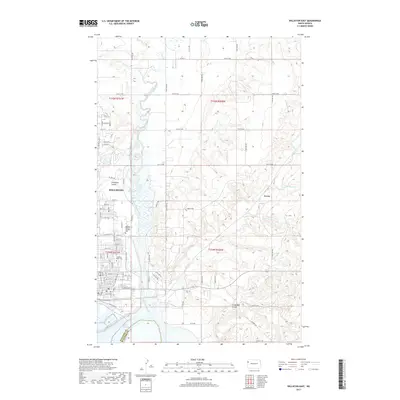
2017 Map of Williston East
USGS Topo · Published 2017About this map
The Williston city limits extend across the Missouri River plateau in this 2017 study, where the northern edges of Lake Sakakawea meet the winding course of the Little Muddy River. The map illustrates a landscape of deep coulees and intermittent drainage, characterized by features like Chinaman Coulee and Crazy Man Coulee that cut through the rolling topography of Williams County. Local institutions and landmarks are clearly identified, including the Williston State Coll campus and the Hillside Memory Gardens Cem on the eastern edge of the city. To the east, the small settlement of Avoca sits near the confluence of Stony Cr and the river. This documentation reveals the intersection of urban growth and the natural hydrology of the plains, showing a dense network of local roads such as E Broadway and Riverside Dr that facilitate travel along the water's edge.
Find a feature on this map
28 named features on this map. Tap any name to fly to it.
Don’t see what you’re looking for? This feature index may not catch every label — zoom into the map to look around manually.
Map Details
Editions of this 2017 Williston East Map
This is the sole edition of this map. No revisions or reprints were ever made.
Other maps of this area

1911 · Ray
USGS Topo · 1:125,000

1953 · Williston
USGS Topo · 1:250,000

1957 · Williston
USGS Topo · 1:250,000

1959 · Marmon SE
USGS Topo · 1:24,000

1959 · Williston West
USGS Topo · 1:24,000

1959 · Williston East
USGS Topo · 1:24,000

1974 · Otter Tail Creek
USGS Topo · 1:24,000

1978 · Lake Jessie
USGS Topo · 1:24,000

1978 · Spring Brook
USGS Topo · 1:24,000
1979 · Stockyard Creek
USGS Topo · 1:24,000