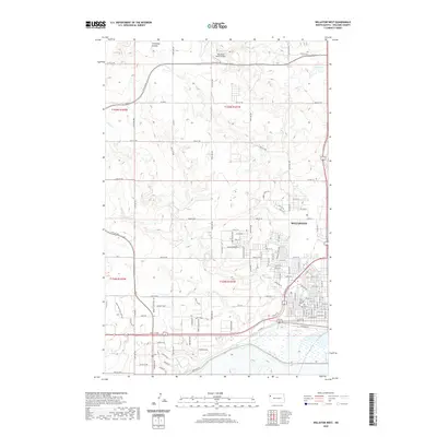
2020 Map of Williston West
USGS Topo · Published 2020About this map
Williston's western edge reveals a modern landscape of residential expansion and rural aviation as it appeared in the late 2010s. The map illustrates a grid of developing streets such as Harvest Hills Dr and Prairie Commons St, showing the transition from agricultural land to suburban settlement. To the north, the terrain is cut by drainage features like Chinaman Coulee and Camp Cr, while the Ring Rock Ranch Airport serves as a distinct landmark in the open prairie of T155N R101W. This survey provides important data for genealogists tracing local families at Saint Joseph Cem and Riverview Cem, both situated near the city's western boundary. The presence of numerous named roads, from Saddle Ridge Cir to major routes like Co Hwy 7, documents the complex transportation network supporting the region's recent growth.
Find a feature on this map
65 named features on this map. Tap any name to fly to it.
Don’t see what you’re looking for? This feature index may not catch every label — zoom into the map to look around manually.
Map Details
Editions of this 2020 Williston West Map
This is the sole edition of this map. No revisions or reprints were ever made.
Other maps of this area

1953 · Williston
USGS Topo · 1:250,000

1957 · Williston
USGS Topo · 1:250,000

1959 · Marmon SE
USGS Topo · 1:24,000

1959 · Williston West
USGS Topo · 1:24,000

1959 · Williston East
USGS Topo · 1:24,000

1969 · Trenton
USGS Topo · 1:24,000

1974 · Otter Tail Creek
USGS Topo · 1:24,000

1974 · Trenton NE
USGS Topo · 1:24,000
1974 · Bonetraill SE
USGS Topo · 1:24,000
1979 · Williston SE
USGS Topo · 1:24,000