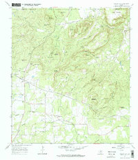
1967 Map of Willow City
USGS Topo · Published 1970About this map
Willow City and the neighboring community of Eckert occupy a landscape defined by the rugged uplift of the Texas Hill Country, situated just south of the boundary between Llano Co and Gillespie Co. The area is marked by a concentration of distinctive peaks and hollows, including the prominent Solomon Mountain and Bee Rock Mountain, which overlook the winding Willow Creek. This 1960s survey captures a transition in local infrastructure, showing the Eckert Pumping Sta and a network of Pipelines running through the hills alongside traditional family-named landmarks like Andy Moore Mountain and Garrett Mountain.
Find a feature on this map
45 named features on this map. Tap any name to fly to it.
Don’t see what you’re looking for? This feature index may not catch every label — zoom into the map to look around manually.
Map Details
Editions of this 1967 Willow City Map
2 editions found
Other maps of this area

1887 · Llano
USGS Topo · 1:125,000

1894 · Fredericksburg
USGS Topo · 1:125,000

1894 · Llano
USGS Topo · 1:125,000

1904 · Llano
USGS Topo · 1:125,000

1909 · Llano
USGS Topo · 1:125,000

1918 · Llano
USGS Topo · 1:125,000

1954 · Llano
USGS Topo · 1:250,000

1955 · Llano
USGS Topo · 1:250,000

1956 · Llano
USGS Topo · 1:250,000

1961 · Cave Creek School
USGS Topo · 1:24,000