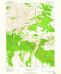
1952 Map of Willow Creek Butte
USGS Topo · Published 1961About this map
Browns Park and the complex high-altitude drainage systems of the Utah-Colorado border define this 1950s survey. The landscape is dominated by the O-Wi-Yu-Kuts Mountains and Cold Spring Mtn, where numerous natural springs like Honeymoon Spring and O-Wi-Yu-Kuts Spring provided critical water sources for local ranching. A single Grave in the northeastern corner and the isolated Willow Creek Ranch to the south serve as quiet markers of human presence in this remote intersection of Daggett and Moffat counties. The map traces the early development of land management in the region, visible through the Irrigation Ditch and a lonely Prospect near Galloway Creek, illustrating how settlers adapted to the high-desert terrain. Other prominent landmarks include the Teepee Mts and the distinct Willow Creek Butte, which overlooks the winding paths of the George Trail.
Find a feature on this map
43 named features on this map. Tap any name to fly to it.
Don’t see what you’re looking for? This feature index may not catch every label — zoom into the map to look around manually.
Map Details
Editions of this 1952 Willow Creek Butte Map
3 editions found
Other maps of this area

1885 · Ashley
USGS Topo · 1:250,000

1952 · Warren Draw
USGS Topo · 1:24,000

1952 · Willow Creek Butte
USGS Topo · 1:24,000

1952 · Swallow Canyon
USGS Topo · 1:24,000

1952 · Clay Basin
USGS Topo · 1:24,000

1954 · Lodore School
USGS Topo · 1:24,000

1954 · Vernal
USGS Topo · 1:250,000

1954 · Rock Springs
USGS Topo · 1:250,000

1958 · Vernal
USGS Topo · 1:250,000

1958 · Rock Springs
USGS Topo · 1:250,000