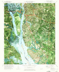
1970 Map of Wilmington
USGS Topo · Published 1973About this map
Wilmington sits at a critical junction of industry and coastal geography, where the Cape Fear River meets the Brunswick River around the low-lying Eagle Island. This orthophotomap provides a clear view of the mid-century harbor infrastructure, including the State Ports Authority and the Seaboard Coast Line rail networks that serviced the city's waterfront. To the east, the landscape transitions from urban grids into residential developments and recreational spaces like Greenfield Park and the Pine Valley Country Club.
Find a feature on this map
42 named features on this map. Tap any name to fly to it.
Don’t see what you’re looking for? This feature index may not catch every label — zoom into the map to look around manually.
Map Details
Editions of this 1970 Wilmington Map
3 editions found
Other maps of this area

1942 · Wilmington
USGS Topo · 1:62,500

1943 · Funston
USGS Topo · 1:24,000

1943 · Winnabow
USGS Topo · 1:24,000

1944 · Winnabow
USGS Topo · 1:31,680

1947 · Rocky Point
USGS Topo · 1:62,500

1948 · Wilmington
USGS Topo · 1:62,500

1950 · Winnabow
USGS Topo · 1:25,000

1953 · Florence
USGS Topo · 1:250,000

1953 · Beaufort
USGS Topo · 1:250,000

1954 · Florence
USGS Topo · 1:250,000