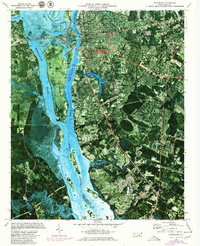
1970 Map of Wilmington
USGS Topo · Published 1980About this map
The Cape Fear River and Brunswick River dominate this orthophotomap, framing the industrial and residential development of Wilmington during the 1970s. The aerial imagery highlights the intricate network of tidal flats and islands, such as Eagle Island and Campbell Island, which separate the city from smaller satellite communities like Navassa, Leland, and Belville. This hybrid map style provides an unusual view of the city's growth, showing the densely packed blocks of neighborhoods like Love Grove alongside large-scale infrastructure like the Seaboard Coast Line railroad and the USS North Carolina Battleship Memorial moored on the riverbank.
Find a feature on this map
42 named features on this map. Tap any name to fly to it.
Don’t see what you’re looking for? This feature index may not catch every label — zoom into the map to look around manually.
Map Details
Editions of this 1970 Wilmington Map
3 editions found
Other maps of this area

1942 · Wilmington
USGS Topo · 1:62,500

1943 · Funston
USGS Topo · 1:24,000

1943 · Winnabow
USGS Topo · 1:24,000

1944 · Winnabow
USGS Topo · 1:31,680

1947 · Rocky Point
USGS Topo · 1:62,500

1948 · Wilmington
USGS Topo · 1:62,500

1950 · Winnabow
USGS Topo · 1:25,000

1953 · Florence
USGS Topo · 1:250,000

1953 · Beaufort
USGS Topo · 1:250,000

1954 · Florence
USGS Topo · 1:250,000