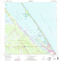
1949 Map of Wilson
USGS Topo · Published 1988About this map
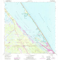
Merritt Island is depicted here at a pivotal transition between its citrus-growing past and its aerospace future. Along the western edge of Mosquito Lagoon, the small settlement of Wilson and the nearby Dummit Grove represent the area's agricultural and local fishing roots, while the purple map revisions from 1977 document the transformation of the landscape into the John F Kennedy Space Center (NASA). This survey captures the encroachment of space exploration infrastructure, such as Launch Complex 39B, upon the barrier island's natural features like Cucumber Slough and Max Hoeck Back Creek. The presence of the US Government RR further illustrates the massive logistics required to build the launch facilities within the Canaveral National Seashore. This record preserves the location of older landmarks like Bull Camp and various unnamed ruins that predated the federal acquisition of the land.
Find a feature on this map
39 named features on this map. Tap any name to fly to it.
Don’t see what you’re looking for? This feature index may not catch every label — zoom into the map to look around manually.
Map Details
Editions of this 1949 Wilson Map
6 editions found
Other maps of this area

1949 · Oak Hill
USGS Topo · 1:24,000

1949 · Pardon Island
USGS Topo · 1:24,000

1949 · Orsino
USGS Topo · 1:24,000

1949 · False Cape
USGS Topo · 1:24,000

1949 · Titusville
USGS Topo · 1:24,000

1949 · Wilson
USGS Topo · 1:24,000

1949 · Mims
USGS Topo · 1:24,000

1951 · False Cape
USGS Topo · 1:24,000

1951 · Orsino
USGS Topo · 1:24,000

1952 · Mims
USGS Topo · 1:24,000