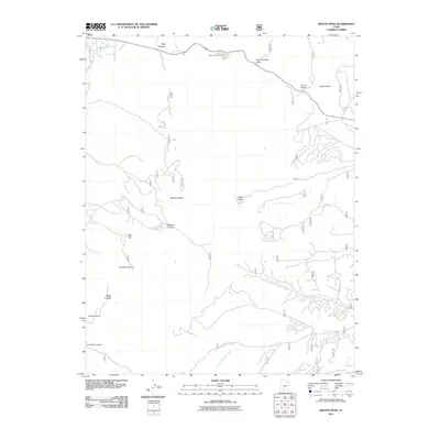
2011 Map of Wilson Peak
USGS Topo · Published 2011About this map
Wilson Peak stands as a central landmark in this high-elevation corner of Garfield County, where a network of deeply incised drainages shapes the landscape. The northern edge is dominated by Red Canyon and its associated Red Canyon Campground, situated along a route designated as a Scenic Dr. This area, managed by the U.S. Forest Service, reveals the complex drainage patterns of the Sevier River and its tributaries, including the branching forks of Blue Fly Creek. Significant topographic variations are reflected in labels like Butch Cassidy Draw, Corral Hollow, and Cabin Hollow, names that echo the ranching and frontier history of southern Utah. The map traces numerous forest roads and trails that navigate the steep terrain between Wilson Canyon and Hillsdale Canyon, providing a precise look at the backcountry infrastructure at the start of the 21st century.
Find a feature on this map
18 named features on this map. Tap any name to fly to it.
Don’t see what you’re looking for? This feature index may not catch every label — zoom into the map to look around manually.
Map Details
Editions of this 2011 Wilson Peak Map
This is the sole edition of this map. No revisions or reprints were ever made.
Other maps of this area

1886 · Kanab
USGS Topo · 1:250,000

1953 · Cedar City
USGS Topo · 1:250,000

1958 · Cedar City
USGS Topo · 1:250,000

1962 · Cedar City
USGS Topo · 1:250,000

1966 · Wilson Peak
USGS Topo · 1:24,000
1966 · Bryce Canyon
USGS Topo · 1:24,000

1966 · Hatch
USGS Topo · 1:24,000

1966 · George Mtn
USGS Topo · 1:24,000
1966 · Tropic Reservoir
USGS Topo · 1:24,000
1966 · Bryce Point
USGS Topo · 1:24,000