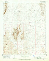
1952 Map of Wind Mesa
USGS Topo · Published 1969About this map
Isleta Pueblo Indian Land Grant dominates this high-altitude landscape southwest of Albuquerque, defined by the geological remnants of ancient volcanic activity. The central landmark is Wind Mesa, a prominent plateau of basaltic Lava that rises above the surrounding plains. The survey, based on 1952 fieldwork with 1967 revisions, captures the intersection of colonial land grants including the Pajarito Grant and the Isleta Pueblo Grant. The terrain is marked by ephemeral drainage systems like Cedar Wash and isolated peaks such as Blackbird Hill. Human presence is sparse and industrial, limited to several Windmill sites and a Quarry in the northwest. In the extreme southeast corner, the A T & S F railroad skirts the edge of the plateau, providing a vital transportation link through this arid region of Bernalillo County.
Find a feature on this map
12 named features on this map. Tap any name to fly to it.
Don’t see what you’re looking for? This feature index may not catch every label — zoom into the map to look around manually.
Map Details
Editions of this 1952 Wind Mesa Map
3 editions found
Other maps of this area

1888 · Bernalillo
USGS Topo · 1:125,000

1889 · Albuquerque
USGS Topo · 1:125,000

1893 · Albuquerque
USGS Topo · 1:125,000

1934 · West Albuquerque
USGS Topo · 1:24,000

1938 · Albuquerque
USGS Topo · 1:62,500

1952 · Wind Mesa
USGS Topo · 1:24,000

1952 · Dalies
USGS Topo · 1:24,000

1952 · Rio Puerco
USGS Topo · 1:24,000

1952 · Los Lunas
USGS Topo · 1:24,000

1952 · Isleta
USGS Topo · 1:24,000