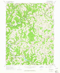
1964 Map of Wind Ridge
USGS Topo · Published 1965About this map
Ryerson Station State Park dominates the southern landscape of this mid-1960s Pennsylvania survey, where the North Fork and South Fork converge at Ryerson Station. The terrain is defined by a dense network of runs and forks, such as Enlow Fork and Dunkard Fork, which shaped the early settlement patterns of West Finley and Richhill townships. This map provides a detailed view of the rural infrastructure of the era, noting numerous compressor stations and gas wells that highlight the region's energy economy.
Find a feature on this map
52 named features on this map. Tap any name to fly to it.
Don’t see what you’re looking for? This feature index may not catch every label — zoom into the map to look around manually.
Map Details
Editions of this 1964 Wind Ridge Map
3 editions found
Other maps of this area

1902 · Wheeling
USGS Topo · 1:62,500

1904 · Cameron
USGS Topo · 1:62,500

1905 · Rogersville
USGS Topo · 1:62,500

1907 · Claysville
USGS Topo · 1:62,500

1935 · Cameron
USGS Topo · 1:62,500

1935 · Wheeling
USGS Topo · 1:62,500

1942 · Cameron
USGS Topo · 1:62,500

1942 · Wheeling
USGS Topo · 1:62,500

1949 · Clarksburg
USGS Topo · 1:250,000

1951 · Canton
USGS Topo · 1:250,000