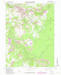
1971 Map of Windber
USGS Topo · Published 1982About this map
Windber and its neighboring boroughs of Scalp Level and Paint sit at the center of an intensive mining and industrial landscape along the border of Cambria and Somerset counties. The presence of numerous strip mines, tipples, and extensive mine dumps across the terrain reflects the region's deep ties to the coal industry. In the valley of Paint Creek, the infrastructure of the Conrail line and the Floodwall protect the settled areas, while landmarks like the Old Shade Furnace point to an even older industrial heritage of iron production in the shaded valleys.
Find a feature on this map
57 named features on this map. Tap any name to fly to it.
Don’t see what you’re looking for? This feature index may not catch every label — zoom into the map to look around manually.
Map Details
Editions of this 1971 Windber Map
4 editions found
Other maps of this area

1902 · Ebensburg
USGS Topo · 1:62,500

1904 · Ebensburg
USGS Topo · 1:62,500

1904 · Johnstown
USGS Topo · 1:62,500

1907 · Johnstown
USGS Topo · 1:62,500

1908 · Bedford
USGS Topo · 1:62,500

1910 · Bedford
USGS Topo · 1:62,500

1914 · Windber
USGS Topo · 1:62,500

1916 · Windber
USGS Topo · 1:62,500

1944 · Windber
USGS Topo · 1:62,500

1953 · Pittsburgh
USGS Topo · 1:250,000