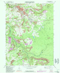
1971 Map of Windber
USGS Topo · Published 1989About this map
Industrial coal culture and mountain geography converge in this 1971 study of the Somerset-Cambria county line. The borough of Windber and its neighbors Scalp Level and Paint are shown in significant detail, revealing the infrastructure of a region built on extraction, from a prominent mine dump to a web of rail connections including Conrail and several stretches of Old Railroad Grade. Institutional life is well-documented through a dense concentration of local landmarks such as SS Peter and Paul Ch and the Maple Grove Sch.
Find a feature on this map
54 named features on this map. Tap any name to fly to it.
Don’t see what you’re looking for? This feature index may not catch every label — zoom into the map to look around manually.
Map Details
Editions of this 1971 Windber Map
4 editions found
Other maps of this area

1902 · Ebensburg
USGS Topo · 1:62,500

1904 · Ebensburg
USGS Topo · 1:62,500

1904 · Johnstown
USGS Topo · 1:62,500

1907 · Johnstown
USGS Topo · 1:62,500

1908 · Bedford
USGS Topo · 1:62,500

1910 · Bedford
USGS Topo · 1:62,500

1914 · Windber
USGS Topo · 1:62,500

1916 · Windber
USGS Topo · 1:62,500

1944 · Windber
USGS Topo · 1:62,500

1953 · Pittsburgh
USGS Topo · 1:250,000