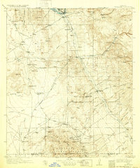
1913 Map of Winkelman
USGS Topo · Published 1932About this map
Mining operations and cattle ranching dominate the arid landscape at the confluence of the Gila River and the San Pedro River. This 1910s survey captures the industrial pulse of the San Pedro Valley, specifically around the mining hub of Mammoth, where the Mammoth Mine, Mohawk Mine, and a Tramway indicate significant subsurface activity. To the south, near the high country of the Coronado National Forest, the settlement of Oracle serves as a gateway to both the mountains and the desert floor.
Find a feature on this map
80 named features on this map. Tap any name to fly to it.
Don’t see what you’re looking for? This feature index may not catch every label — zoom into the map to look around manually.
Map Details
Editions of this 1913 Winkelman Map
4 editions found
Other maps of this area

1900 · Florence
USGS Topo · 1:125,000

1902 · Florence
USGS Topo · 1:125,000

1904 · Tucson
USGS Topo · 1:125,000

1905 · Tucson
USGS Topo · 1:125,000

1910 · Ray
USGS Topo · 1:62,500

1911 · Winkelman
USGS Topo · 1:125,000

1913 · Winkelman
USGS Topo · 1:125,000

1915 · Christmas
USGS Topo · 1:62,500

1917 · Christmas
USGS Topo · 1:62,500

1934 · Tucson Mountains
USGS Topo · 1:125,000