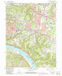
1983 Map of Withamsville
USGS Topo · Published 1987About this map
The Ohio River defines the southern boundary of this region, where the steep bluffs of the Withrow Nature Preserve overlook the water and the Chesapeake and Ohio railroad line. Inland, the landscape transition from the river valley to the expanding suburban reaches of Anderson and Union townships is marked by numerous residential developments and institutional landmarks like St Gregory Seminary and the Coldstream Country Club. This 1980s survey documents a period of significant growth, with new infrastructure such as Interchange 63 and Interchange 64 facilitating the spread of communities like Cherry Grove and Withamsville. Genealogists can locate several burial grounds, including the Newtown Cem and Asbury Cem, while the northern edge near Newtown shows industrial elements like a Gravel Pit and Fish Hatchery along the banks of McCullough Run.
Find a feature on this map
69 named features on this map. Tap any name to fly to it.
Don’t see what you’re looking for? This feature index may not catch every label — zoom into the map to look around manually.
Map Details
Editions of this 1983 Withamsville Map
4 editions found
Other maps of this area

1898 · East Cincinnati
USGS Topo · 1:62,500

1914 · East Cincinnati
USGS Topo · 1:62,500

1914 · Batavia
USGS Topo · 1:48,000

1916 · Batavia
USGS Topo · 1:62,500

1929 · Alexandria
USGS Topo · 1:48,000

1931 · Felicity
USGS Topo · 1:62,500

1936 · Alexandria
USGS Topo · 1:62,500

1952 · Newport
USGS Topo · 1:24,000

1953 · Laurel
USGS Topo · 1:24,000

1953 · Withamsville
USGS Topo · 1:24,000