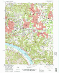
1983 Map of Withamsville
USGS Topo · Published 1992About this map
The Ohio River curves along the southwestern edge of this 1983 revision, serving as a historic boundary between Ohio and Kentucky. In the hills above the river, the transition from early rural settlements to late-century suburban growth is evident in the cluster of institutions like Sacred Heart Seminary and the State Fish Hatchery. The map documents a high density of community landmarks, from the Newtown Cem in the north to the river-bottom settlement of New Palestine. Significant educational and religious centers, including St Veronica Sch and Mt Moriah Ch, are distributed among the residential developments of Withamsville and Cherry Grove. Geologists and local historians can trace the numerous drainage systems, such as Eightmile Creek and Tenmile Creek, which historically dictated the winding path of local roads like Clough Pike.
Find a feature on this map
62 named features on this map. Tap any name to fly to it.
Don’t see what you’re looking for? This feature index may not catch every label — zoom into the map to look around manually.
Map Details
Editions of this 1983 Withamsville Map
4 editions found
Other maps of this area

1898 · East Cincinnati
USGS Topo · 1:62,500

1914 · East Cincinnati
USGS Topo · 1:62,500

1914 · Batavia
USGS Topo · 1:48,000

1916 · Batavia
USGS Topo · 1:62,500

1929 · Alexandria
USGS Topo · 1:48,000

1931 · Felicity
USGS Topo · 1:62,500

1936 · Alexandria
USGS Topo · 1:62,500

1952 · Newport
USGS Topo · 1:24,000

1953 · Laurel
USGS Topo · 1:24,000

1953 · Withamsville
USGS Topo · 1:24,000