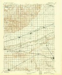
1896 Map of Wood River
USGS Topo · Published 1932About this map
The Platte River corridor dominates this central Nebraska landscape, bifurcating into the North Channel, Middle Channel, and South Channel to form a complex system of riverine islands including Grand Island and Drover Island. The region's development is closely tied to the iron horse, with the Union Pacific R. R. and several branches of the Burlington and Missouri River R. R. dictating the placement of grain-and-rail towns. Primary hubs like Wood River, Shelton, and Gibbon appear along the northern tracks, while Minden and Kenesaw anchor the agricultural plains to the south. Notable river infrastructure such as the Wood River Bridge and Shelton Bridge facilitate movement across the shifting braids of the Platte. The map also captures several townships and smaller communities including Juniata, Newark, and Prosser during a period of steady prairie expansion.
Find a feature on this map
75 named features on this map. Tap any name to fly to it.
Don’t see what you’re looking for? This feature index may not catch every label — zoom into the map to look around manually.
Map Details
Editions of this 1896 Wood River Map
4 editions found
Other maps of this area

1892 · Grand Island
USGS Topo · 1:62,500

1894 · Kenesaw
USGS Topo · 1:62,500

1894 · Kearney
USGS Topo · 1:62,500

1894 · Minden
USGS Topo · 1:62,500

1895 · Grand Island
USGS Topo · 1:62,500

1895 · Wood River
USGS Topo · 1:62,500

1896 · Holdrege
USGS Topo · 1:125,000

1896 · Kearney
USGS Topo · 1:125,000

1896 · Wood River
USGS Topo · 1:125,000

1897 · Red Cloud
USGS Topo · 1:125,000