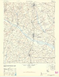
1946 Map of Woodford
USGS Topo · Published 1946About this map
The Seaboard Railway corridor dictates the development of central South Carolina in this wartime-era survey, connecting the settlements of Swansea, Woodford, North, Livingston, and Neeses. This linear progression of towns reflects the critical role of rail transport in the rural economy, where millponds like Brooker Millpond and Etheredge Millpond dot the landscape, indicating a long-standing reliance on local water power for timber or grist operations.
Find a feature on this map
111 named features on this map. Tap any name to fly to it.
Don’t see what you’re looking for? This feature index may not catch every label — zoom into the map to look around manually.
Map Details
Editions of this 1946 Woodford Map
3 editions found

Other maps of this area

1919 · Bamberg
USGS Topo · 1:48,000

1920 · Bamberg
USGS Topo · 1:62,500

1920 · Orangeburg
USGS Topo · 1:48,000

1921 · Orangeburg
USGS Topo · 1:62,500

1923 · Williston
USGS Topo · 1:48,000

1927 · Williston
USGS Topo · 1:62,500

1943 · Bamberg
USGS Topo · 1:62,500

1943 · Orangeburg
USGS Topo · 1:125,000

1943 · Williston
USGS Topo · 1:62,500

1943 · Orangeburg
USGS Topo · 1:62,500