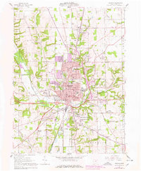
1961 Map of Wooster
USGS Topo · Published 1978About this map
Wooster serves as a dense hub of education and institutional research on this 1960s landscape, anchored by the College of Wooster and the sprawling Ohio Agricultural Experiment Station. The city's residential growth is evident near Christmas Run Park and the Wooster Plaza Shopping Center, while its outskirts maintain smaller historic clusters like Madisonburg and the curiously named Devil Town.
Find a feature on this map
74 named features on this map. Tap any name to fly to it.
Don’t see what you’re looking for? This feature index may not catch every label — zoom into the map to look around manually.
Map Details
Editions of this 1961 Wooster Map
4 editions found
Other maps of this area

1901 · Wooster
USGS Topo · 1:62,500

1903 · Wooster
USGS Topo · 1:62,500

1906 · West Salem
USGS Topo · 1:62,500

1908 · West Salem
USGS Topo · 1:62,500

1912 · Loudonville
USGS Topo · 1:62,500

1914 · Loudonville
USGS Topo · 1:62,500

1915 · Millersburg
USGS Topo · 1:62,500

1943 · Millersburg
USGS Topo · 1:62,500

1943 · Loudonville
USGS Topo · 1:62,500

1950 · Marion
USGS Topo · 1:250,000