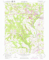
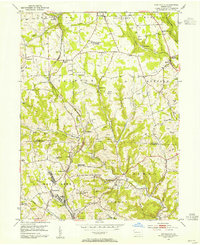
1958 Map of Worthington
USGS Topo · Published 1979About this map
Worthington and the industrial corridors of the Baltimore and Ohio railroad define this landscape at the intersection of Armstrong and Butler counties. The 1958 survey, updated with 1970s revisions, highlights a region shaped by resource extraction and early milling, with numerous strip mines, a Quarry, and a Mine Tipple dotting the hillsides near Buffalo Creek. Local genealogy and community history are anchored by smaller settlements such as West Winfield, Fenelton, and Slate Lick, alongside rural landmarks like McKee Chapel and St Johns Ch. The map captures the transition from traditional water-powered sites like Buffalo Mills and Dennys Mills to modern infrastructure, including a prominent Television Tower and the expansion of the Benjamin Franklin Highway. This detailed record provides a clear view of mid-century Pennsylvania life, where township schools and family-named runs like Sipes Run and Cornplanter Run delineate the historic countryside.
Find a feature on this map
42 named features on this map. Tap any name to fly to it.
Don’t see what you’re looking for? This feature index may not catch every label — zoom into the map to look around manually.
Map Details
Editions of this 1958 Worthington Map
4 editions found
Other maps of this area

1900 · Kittanning
USGS Topo · 1:62,500

1902 · Kittanning
USGS Topo · 1:62,500

1907 · Freeport
USGS Topo · 1:62,500

1908 · New Kensington
USGS Topo · 1:62,500

1909 · Freeport
USGS Topo · 1:62,500

1909 · Butler
USGS Topo · 1:62,500

1910 · New Kensington
USGS Topo · 1:62,500

1911 · Butler
USGS Topo · 1:62,500

1953 · Pittsburgh
USGS Topo · 1:250,000
1953 · Curtisville
USGS Topo · 1:24,000