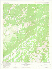
1957 Map of X LAZY F RANCH
USGS Topo · Published 1965About this map
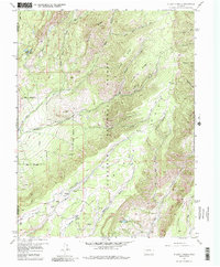
The X Lazy F Ranch serves as a primary point of human settlement in this high-altitude landscape on the border of Montrose and Gunnison Counties. Established within the boundaries of the Gunnison National Forest, the terrain is defined by the massive plateau of Black Mesa and its sister formation, Soap Mesa, to the southeast. A complex system of drainage is evident through numerous waterways such as Curecanti Creek, Crystal Creek, and West Dyer Creek, which carve deep gulches like Hartman Gulch and Myers Gulch between prominent features like Bellmire Ridge and Powell Ridge.
Find a feature on this map
33 named features on this map. Tap any name to fly to it.
Don’t see what you’re looking for? This feature index may not catch every label — zoom into the map to look around manually.
Map Details
Editions of this 1957 X LAZY F RANCH Map
6 editions found

Other maps of this area

1908 · Uncompahgre
USGS Topo · 1:125,000

1909 · Montrose
USGS Topo · 1:125,000

1911 · Uncompahgre
USGS Topo · 1:125,000

1911 · Montrose
USGS Topo · 1:125,000

1954 · Little Soap Park
USGS Topo · 1:24,000

1954 · Sapinero
USGS Topo · 1:24,000

1956 · Curecanti Needle
USGS Topo · 1:24,000

1956 · Cimarron
USGS Topo · 1:24,000

1956 · Montrose
USGS Topo · 1:250,000

1957 · Cathedral Peak
USGS Topo · 1:24,000