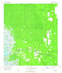
1955 Map of Yankeetown
USGS Topo · Published 1963About this map
The dense, swampy forests of Gulf Hammock define this coastal landscape where the Withlacoochee River meets the Gulf of Mexico. This 1955 survey illustrates a specific period of early development along the Levy and Citrus county line, centered on the riverfront settlements of Yankeetown, Crackertown, and Inglis. The map reveals the intricate hydrology of the region, from the massive Spring Run and Big Spring in the north to the maze of tidal channels like Sandfly Creek and Thousandmile Creek near the coast.
Find a feature on this map
39 named features on this map. Tap any name to fly to it.
Don’t see what you’re looking for? This feature index may not catch every label — zoom into the map to look around manually.
Map Details
Editions of this 1955 Yankeetown Map
5 editions found
Other maps of this area

1954 · Crystal River
USGS Topo · 1:24,000

1954 · Red Level
USGS Topo · 1:24,000

1954 · Yankeetown SE
USGS Topo · 1:24,000

1954 · Gainesville
USGS Topo · 1:250,000

1955 · Lebanon Station
USGS Topo · 1:24,000

1955 · Withlacoochee Bay
USGS Topo · 1:24,000

1955 · Waccasassa Bay
USGS Topo · 1:24,000

1955 · Yankeetown
USGS Topo · 1:24,000

1955 · Tidewater
USGS Topo · 1:24,000

1955 · Plant City
USGS Topo · 1:250,000