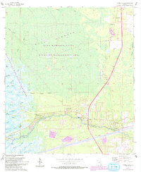
1955 Map of Yankeetown
USGS Topo · Published 1993About this map
Yankeetown and the neighboring settlements of Crackertown and Inglis anchor this coastal landscape where the Withlacoochee River meets the Gulf of Mexico. The map reveals a complex hydrologic network of tidal creeks, including Smith Creek, Thousandmile Creek, and Helverson Creek, winding through the Waccasassa Bay State Preserve. To the north, the vast Gulf Hammock State Wildlife Management Area dominates the terrain, punctuated by features like Big Spring and Little Spring.
Find a feature on this map
40 named features on this map. Tap any name to fly to it.
Don’t see what you’re looking for? This feature index may not catch every label — zoom into the map to look around manually.
Map Details
Editions of this 1955 Yankeetown Map
5 editions found
Other maps of this area

1954 · Crystal River
USGS Topo · 1:24,000

1954 · Red Level
USGS Topo · 1:24,000

1954 · Yankeetown SE
USGS Topo · 1:24,000

1954 · Gainesville
USGS Topo · 1:250,000

1955 · Lebanon Station
USGS Topo · 1:24,000

1955 · Withlacoochee Bay
USGS Topo · 1:24,000

1955 · Waccasassa Bay
USGS Topo · 1:24,000

1955 · Yankeetown
USGS Topo · 1:24,000

1955 · Tidewater
USGS Topo · 1:24,000

1955 · Plant City
USGS Topo · 1:250,000