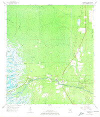
1955 Map of Yankeetown
USGS Topo · Published 1972About this map
The Withlacoochee River serves as the central artery for this coastal landscape, winding past the settlements of Yankeetown, Crackertown, and Inglis as it approaches the Gulf. The 1955 survey data illustrates a community deeply integrated with its watery surroundings, where the Yankeetown Town Boundary encompasses a network of labyrinthine coastal inlets and marshy features like Helverson Island and Pats Elbow.
Find a feature on this map
38 named features on this map. Tap any name to fly to it.
Don’t see what you’re looking for? This feature index may not catch every label — zoom into the map to look around manually.
Map Details
Editions of this 1955 Yankeetown Map
5 editions found
Other maps of this area

1954 · Crystal River
USGS Topo · 1:24,000

1954 · Red Level
USGS Topo · 1:24,000

1954 · Yankeetown SE
USGS Topo · 1:24,000

1954 · Gainesville
USGS Topo · 1:250,000

1955 · Lebanon Station
USGS Topo · 1:24,000

1955 · Withlacoochee Bay
USGS Topo · 1:24,000

1955 · Waccasassa Bay
USGS Topo · 1:24,000

1955 · Yankeetown
USGS Topo · 1:24,000

1955 · Tidewater
USGS Topo · 1:24,000

1955 · Plant City
USGS Topo · 1:250,000