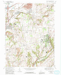
1968 Map of Yellow Springs
USGS Topo · Published 1992About this map
Antioch College serves as a cultural and intellectual anchor within Yellow Springs, a town defined by its proximity to the Little Miami River and the expansive Little Miami State Forest Preserve. This 1968 revision captures the region during a period of suburban transition, showing established residential pockets like Holiday Valley and Houck Meadows alongside the older crossroads of Byron and Enon. The landscape is etched with the legacies of local education and faith, featuring sites such as Indian Valley Sch, Hustead Sch, and the Byron Ch Cem. Transportation patterns are dominated by the Conrail lines and the developing infrastructure around Fairborn, while conservation efforts are evident in the protected lands of the Beaver Creek State Wildlife Area and Twin Towers (County Park).
Find a feature on this map
52 named features on this map. Tap any name to fly to it.
Don’t see what you’re looking for? This feature index may not catch every label — zoom into the map to look around manually.
Map Details
Editions of this 1968 Yellow Springs Map
4 editions found
Other maps of this area

1904 · Springfield
USGS Topo · 1:62,500

1904 · Dayton
USGS Topo · 1:62,500

1906 · Dayton
USGS Topo · 1:62,500

1906 · Springfield
USGS Topo · 1:62,500

1913 · Waynesville
USGS Topo · 1:62,500

1915 · Waynesville
USGS Topo · 1:62,500

1917 · Xenia
USGS Topo · 1:62,500

1947 · Columbus
USGS Topo · 1:250,000

1953 · Cincinnati
USGS Topo · 1:250,000

1954 · Clifton
USGS Topo · 1:24,000