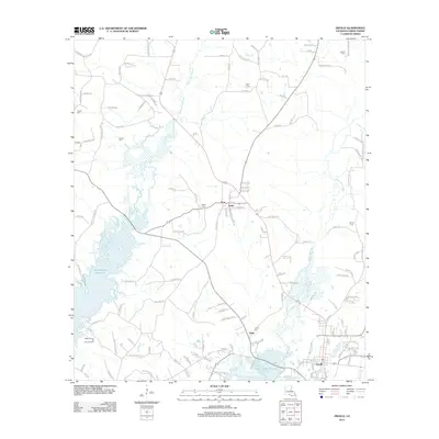
2012 Map of Zwolle
USGS Topo · Published 2012About this map
Zwolle serves as the primary hub in this portion of Sabine Parish, situated where regional roads converge near the southern edge of the survey. The landscape is defined by the expansive waters of the Toledo Bend Reservoir, which dominates the western and southwestern sections, and the complex drainage of Bayou San Patricio and Bayou San Miguel. Smaller settlements like Noble and Clyde appear alongside significant local landmarks, including the Ebarb School and an Oil and Gas Field, indicating the area's dual reliance on educational infrastructure and natural resource extraction. Numerous family and community burial grounds, such as Noble Cem, Shiloh Cem, and Sardis Cem, are scattered across the terrain, providing essential reference points for genealogists tracing early twentieth-century parish history. The network of rural routes like Sardis Cemetery Rd and Mobley Ford Ln underscores the historical connectivity between these upland communities and the river-bottom lands.
Find a feature on this map
132 named features on this map. Tap any name to fly to it.
Don’t see what you’re looking for? This feature index may not catch every label — zoom into the map to look around manually.
Map Details
Editions of this 2012 Zwolle Map
This is the sole edition of this map. No revisions or reprints were ever made.
Other maps of this area

1941 · Zwolle
USGS Topo · 1:62,500

1941 · Pelican
USGS Topo · 1:62,500

1943 · Pleasant Hill
USGS Topo · 1:62,500

1944 · Logansport
USGS Topo · 1:62,500

1944 · Patroon
USGS Topo · 1:62,500

1944 · Zwolle
USGS Topo · 1:62,500

1944 · Pleasant Hill
USGS Topo · 1:62,500

1953 · Alexandria
USGS Topo · 1:250,000

1955 · Alexandria
USGS Topo · 1:250,000

1956 · Logansport
USGS Topo · 1:62,500