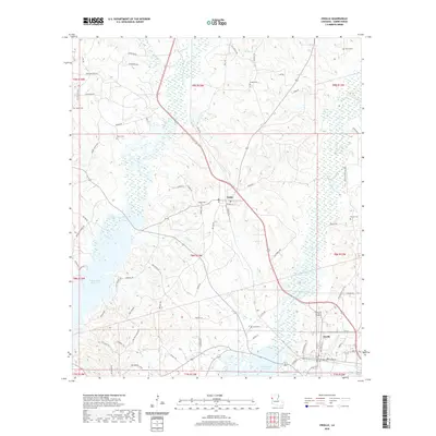
2020 Map of Zwolle
USGS Topo · Published 2020About this map
Zwolle and Noble anchor this Sabine Parish landscape, where the rising waters of the Toledo Bend Reservoir meet a network of bayous and wetlands. The terrain is defined by the winding paths of Bayou San Miguel and Bayou San Patricio, which feed into the reservoir along the western and southern reaches of the quadrangle. This 2020 data captures the area's rural character, dominated by timberlands and a high density of small family and community burial grounds that speak to the region's deep roots. Scattered across the hills are numerous named cemeteries, including Shiloh Cem and Sardis Cem in the north, while Noble Cem and Clyde Cem are located near the primary settlements. The transport network relies on a mix of state routes and named local roads like Old Pleasant Hill Rd and Bird Creek Rd, tracing the high ground between the low-lying bayou bottoms.
Find a feature on this map
76 named features on this map. Tap any name to fly to it.
Don’t see what you’re looking for? This feature index may not catch every label — zoom into the map to look around manually.
Map Details
Editions of this 2020 Zwolle Map
This is the sole edition of this map. No revisions or reprints were ever made.
Other maps of this area

1941 · Zwolle
USGS Topo · 1:62,500

1941 · Pelican
USGS Topo · 1:62,500

1943 · Pleasant Hill
USGS Topo · 1:62,500

1944 · Logansport
USGS Topo · 1:62,500

1944 · Patroon
USGS Topo · 1:62,500

1944 · Zwolle
USGS Topo · 1:62,500

1944 · Pleasant Hill
USGS Topo · 1:62,500

1953 · Alexandria
USGS Topo · 1:250,000

1955 · Alexandria
USGS Topo · 1:250,000

1956 · Logansport
USGS Topo · 1:62,500