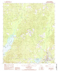
1988 Map of Zwolle
USGS Topo · Published 1988About this map
The town of Zwolle serves as the primary hub of this Sabine Parish landscape, situated near the headwaters of the Toledo Bend Reservoir. This 1980s survey captures the area as the artificial lake's western shoreline defined the local geography, providing public access points such as a Boat Ramp and a highway Rest Area. North of town, the settlement of Noble sits within a network of winding waterways including San Patricio Bayou and Spring Branch. The map details the local drainage patterns typical of this Louisiana region, where Bayou San Miguel and Bayou Scie snake through the terrain. Evidence of the community's established history is found in several rural Cem sites and a prominent Radio Tower, reflecting a mix of traditional land use and mid-century utility infrastructure.
Find a feature on this map
12 named features on this map. Tap any name to fly to it.
Don’t see what you’re looking for? This feature index may not catch every label — zoom into the map to look around manually.
Map Details
Editions of this 1988 Zwolle Map
This is the sole edition of this map. No revisions or reprints were ever made.
Other maps of this area

1941 · Zwolle
USGS Topo · 1:62,500

1941 · Pelican
USGS Topo · 1:62,500

1943 · Pleasant Hill
USGS Topo · 1:62,500

1944 · Logansport
USGS Topo · 1:62,500

1944 · Patroon
USGS Topo · 1:62,500

1944 · Zwolle
USGS Topo · 1:62,500

1944 · Pleasant Hill
USGS Topo · 1:62,500

1953 · Alexandria
USGS Topo · 1:250,000

1955 · Alexandria
USGS Topo · 1:250,000

1956 · Logansport
USGS Topo · 1:62,500