1990s Maps of Matanuska-Susitna, Alaska
Explore 38 historic maps of Matanuska-Susitna from the 1990s. These maps offer a rare glimpse into what life looked like during the 1990s — showing old roads, neighborhoods, homes, and landmarks that have changed or disappeared over time.
Whether you're researching your family's past, planning a metal detecting trip, or studying how Matanuska-Susitna's landscape evolved across the 1990s, these high-resolution maps are a powerful tool for exploring the history of this region.
- Focus on a specific era: All maps on this page are from the 1990s, giving you a focused view of this time period.
- See what’s changed: Compare century-old streets, trails, and buildings to today's modern landscape using overlays and satellite layers.
- Research with precision: Use these maps for genealogy, historical research, land use analysis, or educational projects.
- View, download, or print: Maps are fully viewable online in high resolution, and can be downloaded or printed for your own records.
Start exploring Matanuska-Susitna's history through authentic maps from the 1990s. This is your window into the past.
Matanuska-Susitna, AK maps
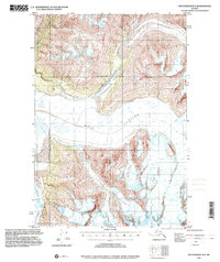
(38)- 1992 Map of Anchorage C-7 SE
 1992 Anchorage C-7 SE1992 Print · USGSWasilla and its surrounding lakes are captured during a period of significant growth in the early nineties. Genealogists and local historians can locate established institutions like Iditarod Sch, the University of Alaska Experimental Farm, and the shoreline of Finger Lake.
 - 1992 Map of Anchorage C-8 SE
 1992 Anchorage C-8 SE1992 Print · USGSThe Susitna Valley in the early nineties shows a landscape of expanding settlements and bush aviation. Genealogists and local historians can trace the growth of Houston and Pittman or locate family properties near Threemile Lake and Settlers Bay Landing Strip.
 - 1992 Map of Anchorage C-7 SW
 1992 Anchorage C-7 SW1992 Print · USGSWasilla and the surrounding Matanuska-Susitna Valley are captured here during a decade of rapid growth in the early nineties. Genealogists and researchers can trace local landmarks like Iditarod Sch, Lake Lucile, and the sprawling Palmer Hay Flats.
 - 1992 Map of Anchorage C-6 SW
 1992 Anchorage C-6 SW1992 Print · USGSThe Matanuska Valley's development is documented in the early nineties as the community around Palmer continued to grow. Researchers can trace the layout of the University of Alaska Experimental Farm, locate the Palmer Pioneer Cemetery, and follow the Old Railroad Grade.
 - 1993 Map of Anchorage C-2, 2001 Print
 1993 Anchorage C-22001 Print · USGSThe glacial landscape of the Matanuska-Susitna Borough is captured in the early 1990s, showcasing the intricate flow of the Matanuska Glacier. Researchers can trace the ice fields and surrounding summits like Mount Wickersham and the cluster of Denmark Peak and Sweden Peak.
 - 1993 Map of Tyonek D-1, 2001 Print
 1993 Tyonek D-12001 Print · USGSThe Susitna River valley in the early nineties shows a landscape of braided rivers and highway settlements connected by the George Parks Highway. Researchers can trace the development of Willow and Kashwitna, or locate specialized sites like the Willow Airport and Willow Creek Campground.
 - 1993 Map of Anchorage D-2, 2001 Print
 1993 Anchorage D-22001 Print · USGSThe Matanuska-Susitna region in the 1990s showcases a rugged interior landscape shaped by the Matanuska Glacier and alpine topography. Researchers can trace the path of the Glenn Highway to find local landmarks like Meekins Roadhouse, Sheep Mountain Lodge, and the prominent Lion Head.
 - 1993 Map of Anchorage C-3, 2001 Print
 1993 Anchorage C-32001 Print · USGSThe high peaks and ice fields of the Matanuska-Susitna region are captured here in the early nineties, showing a landscape shaped by glacial flow. Researchers can trace the drainage of Gravel Creek, identify the heights of Mount Sergeant Robinson, and locate the fields of Crevasses.
 - 1993 Map of Tyonek D-3, 2001 Print
 1993 Tyonek D-32001 Print · USGSThe Matanuska-Susitna interior in the 1990s remained a landscape of seasonal routes and river-based life. You can trace the Iditarod Trail (Approximate) and search for isolated cabins near McDougal and the shores of Alexander Lake.
 - 1993 Map of Tyonek D-4, 2001 Print
 1993 Tyonek D-42001 Print · USGSThe Skwentna and Yentna rivers meet in this 1990s wilderness survey, where aviation and river travel define the landscape. Trace the Iditarod Trail, the Old Skwentna Road House (Site), and remote outposts like Whiskey Lake.
 - 1993 Map of Anchorage D-1, 2001 Print
 1993 Anchorage D-12001 Print · USGSThe Glenn Highway corridor near the Matanuska River is captured here in the early nineties as a landscape of roadhouses and glacial rivers. Researchers can locate the Eureka Roadhouse, trace the terminal edge of the Nelchina Glacier, and find remote Landing Strips and Cabins.
 - 1993 Map of Tyonek D-2, 2001 Print
 1993 Tyonek D-22001 Print · USGSThe Matanuska-Susitna wilderness in the early nineties is defined here by its massive river systems and seasonal trails. Researchers can trace remote routes like the Winter Trail or locate isolated landmarks such as Neil Lake and a solitary Cabin.
 - 1993 Map of Valdez D-8, 2001 Print
 1993 Valdez D-82001 Print · USGSThe Matanuska-Susitna region is shown in the early nineties as a landscape of high ridges and glacial water. Researchers can trace the path of the Glenn Highway past a Campground and remote landmarks like Heavenly Ridge.
 - 1993 Map of Anchorage D-3, 2001 Print
 1993 Anchorage D-32001 Print · USGSThe Matanuska-Susitna region in the early nineties shows a rugged landscape where the Glenn Highway cuts through the mountains. Researchers can find remote landmarks like the Watchtower Inn, the Matanuska Glacier, and Hundred Mile Lake.
 - 1993 Map of Tyonek C-1, 2002 Print
 1993 Tyonek C-12002 Print · USGSThe Susitna Valley in the early 1990s shows a landscape of wilderness transit, from the historic Iditarod Trail to the Parks Highway. Researchers can trace remote Cabins along the Deshka River and the development surrounding Willow Airport.
 - 1993 Map of Tyonek C-3, 2002 Print
 1993 Tyonek C-32002 Print · USGSThe Matanuska-Susitna backcountry is documented here during the early nineties, showing a landscape defined by expansive wetlands and isolated peaks. Trace the historic route of the Iditarod Trail as it passes near Alexander Lake and the remote outpost at Texas.
 - 1993 Map of Tyonek C-2, 2002 Print
 1993 Tyonek C-22002 Print · USGSThe Iditarod Trail winds through this river-rich wilderness during the 1990s, documenting a landscape of seasonal outposts and glacial waterways. Genealogists and researchers can locate remote Cabins, a small Cem, and the Winter Landing Strip along the Yentna River.
 - 1993 Map of Valdez C-8, 2002 Print
 1993 Valdez C-82002 Print · USGSThe northern reaches of the Nelchina region are captured here in the early nineties, revealing the immense scale of the Nelchina Glacier. Researchers can trace the drainage patterns of Klanelneechena Creek and locate complex fields of crevasses.
 - 1994 Map of Talkeetna B-2, 2000 Print
 1994 Talkeetna B-22000 Print · USGSNear the Peters Hills in the mid-1990s, the landscape remains defined by its mining heritage and remote wilderness. Researchers can trace the extensive Placer Mines along Cache Creek or locate the settlement of Petersville and its Landing Strip.
 - 1994 Map of Talkeetna A-2, 2000 Print
 1994 Talkeetna A-22000 Print · USGSThe Matanuska-Susitna interior in the 1990s is captured here as a sprawling network of wetlands and rivers. Researchers can trace the winding course of the Kahiltna River and locate remote outposts like the cabins near Shulin Lake and Amber Lake.
 - 1994 Map of Anchorage B-4, 2001 Print
 1994 Anchorage B-42001 Print · USGSThe glacial wilderness east of Anchorage comes into focus in the mid-1990s at the intersection of two boroughs. Researchers can trace the massive Knik Glacier, the waters of Inner Lake George, and a remote Landing Strip.
 - 1994 Map of Anchorage C-4, 2001 Print
 1994 Anchorage C-42001 Print · USGSThe Chugach Mountains and their massive ice fields are captured here in the mid-1990s, following decades of topographic observation. Researchers can trace the extensive reach of the Metal Creek Glacier and the headwaters of Carbon Creek and Coal Creek.
 - 1994 Map of Anchorage D-4, 2001 Print
 1994 Anchorage D-42001 Print · USGSThe Matanuska Valley and its surrounding peaks were being meticulously mapped in the 1990s as modern access expanded into the interior. Researchers can trace the Knik Nelchina Trail and locate remote outposts like Ninemile Cabin and the Ninety-eight Bridge.
 - 1994 Map of Anchorage C-5, 2002 Print
 1994 Anchorage C-52002 Print · USGSThe Matanuska Valley and its surrounding peaks are captured here in the mid-1990s as the regional transportation network evolved. Researchers can trace the path of the Glenn Highway and identify remote landmarks like Pinnacle Mountain and the Landing Strip.
 - 1994 Map of Talkeetna A-1, 2002 Print
 1994 Talkeetna A-12002 Print · USGSThe Susitna River valley in the mid-1990s shows a landscape defined by the George Parks Highway and a network of interior trails. Researchers can trace remote settlements and unique local landmarks like Section House, the Birch Creek Slough, and Question Lake.
Showing maps 1-25 of 38
Top cities of Matanuska-Susitna
- Wasilla historical maps
- Palmer historical maps
- Big Lake historical maps
- Willow historical maps
- Houston historical maps
- Talkeetna historical maps
See more
Frequently asked questions
- What are the different types of historical maps available for Matanuska-Susitna?
- What is the oldest map of Matanuska-Susitna?
- Where can I purchase historical maps of Matanuska-Susitna for my home or office?
- Where can I download high-res historical maps of Matanuska-Susitna?
- Are there historical topographic maps available for Matanuska-Susitna?
- Is there historical aerial imagery available for Matanuska-Susitna?
- Where are historical maps of Matanuska-Susitna sourced from?