1950s Maps of Pima County, Arizona
Explore 41 historic maps of Pima County from the 1950s. These maps offer a rare glimpse into what life looked like during the 1950s — showing old roads, neighborhoods, homes, and landmarks that have changed or disappeared over time.
Whether you're researching your family's past, planning a metal detecting trip, or studying how Pima County's landscape evolved across the 1950s, these high-resolution maps are a powerful tool for exploring the history of this region.
- Focus on a specific era: All maps on this page are from the 1950s, giving you a focused view of this time period.
- See what’s changed: Compare century-old streets, trails, and buildings to today's modern landscape using overlays and satellite layers.
- Research with precision: Use these maps for genealogy, historical research, land use analysis, or educational projects.
- View, download, or print: Maps are fully viewable online in high resolution, and can be downloaded or printed for your own records.
Start exploring Pima County's history through authentic maps from the 1950s. This is your window into the past.
Pima County, AZ maps
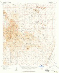
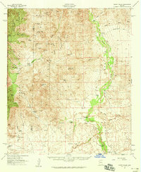
(41)- 1951 Map of Mammoth
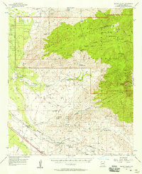
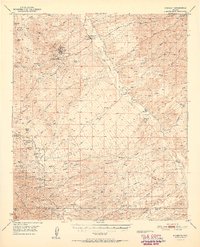 1951 Mammoth1951 Print · USGSThe mining and ranching culture of southern Arizona is captured here at mid-century, before the San Manuel smelter transformed the valley. Genealogists and researchers can trace family-named sites like Kannally Ranch, the remote American Flag Ranch, and workings at Tiger.2 unique versions available
 - 1953 Map of Ajo, 1971 Print
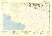
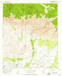
 1953 Ajo1971 Print · USGSThe Arizona desert at mid-century reveals a landscape of massive copper mines, tribal reservations, and military testing grounds. Genealogists and historians can trace rail stopovers like Dateland and Mohawk or locate remote sites like the Reward Mine and Gu Achi (Santa Rosa).2 unique versions available
 - 1954 Map of Sonoyta
 1954 Sonoyta1954 Print · USGSThe Arizona-Sonora borderlands come into focus in the 1950s, showing a landscape of volcanic craters and remote desert outposts. Trace the cattle-ranching and Indigenous history of the region through sites like Cervantls Well and Ali Ak Chin.
 - 1956 Map of Nogales, 1963 Print
 1956 Nogales1963 Print · USGSSouthern Arizona in the mid-fifties is captured here from the Papago tribal lands to the San Pedro valley. Genealogists and historians can trace border settlements like Sasabe, the legacy of Tombstone, and old mining sites including the Mary G Mine.4 unique versions available
 - 1956 Map of Tucson, 1967 Print
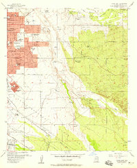
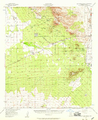
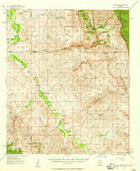
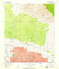
 1956 Tucson1967 Print · USGSPost-war Southern Arizona comes into focus as the copper and aviation industries expand around Tucson. Trace family roots in South Tucson or locate early mining sites like the San Manuel Mine and Silver Bell Mine near the Santa Cruz River.3 unique versions available
 - 1957 Map of Ajo
 1957 Ajo1957 Print · USGSSouthern Arizona in the fifties reveals a landscape of massive copper mines, remote desert wells, and tribal reservations. Genealogists and historians can trace old cattle outposts like Whitewing Ranch, the Tracy's Trading Post, and the copper works at Ajo.
 - 1957 Map of Tucson East, 1958 Print
 1957 Tucson East1958 Print · USGSThe eastern fringes of Tucson were rapidly expanding in the late fifties as residential neighborhoods pushed toward the desert washes. Genealogists and historians can locate numerous early schools like Treehaven Sch and the expansive Davis-Monthan Air Force Base.4 unique versions available
 - 1957 Map of Tubac, 1958 Print
 1957 Tubac1958 Print · USGSThe Santa Cruz River valley comes alive in the late fifties, showing the ranches and railroads of southern Arizona. Researchers can trace family history at Amado P O, the Sopori Sch, and early sites like El Canto Ranch or Tubac.3 unique versions available
 - 1957 Map of Twin Buttes, 1958 Print
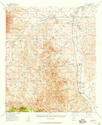
 1957 Twin Buttes1958 Print · USGSSouthern Arizona in the late fifties shows a landscape of expansive cattle ranches and growing industrial copper mines. Genealogists and historians can trace family-named holdings like McGee Ranch or explore the operations at Banner Mine and San Xavier.4 unique versions available
 - 1957 Map of San Xavier Mission, 1958 Print
 1957 San Xavier Mission1958 Print · USGSThe desert landscape south of Tucson comes alive in the late fifties, dominated by the Tucson Mountains and the Santa Cruz River valley. Genealogists and historians can trace the foundations of the San Xavier del Bac Mission, the Arizona-Sonora Desert Museum, and early regional airstrips like Ryan Field.2 unique versions available
 - 1957 Map of Bellota Ranch, 1958 Print
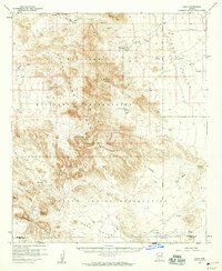
 1957 Bellota Ranch1958 Print · USGSThe Santa Catalina Mountains during the late fifties show a transition from heavy mining to federal land management and forest recreation. You can trace early canyon settlements and industrial sites like the Hartman Mine Group, Bellota Ranch, and the Federal Honor Camp.4 unique versions available
 - 1957 Map of Tucson, 1958 Print
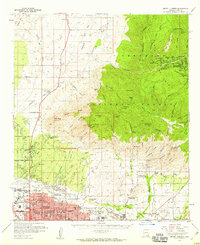
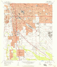 1957 Tucson1958 Print · USGSMid-century Tucson is seen here during a decade of massive growth, from the university campus to the airfield. Genealogists and historians can trace neighborhood development near Pascua Yaqui Indian Village, Emery Park, and the Davis Monthan Air Force Base.3 unique versions available
 - 1957 Map of Tucson, 1958 Print
 1957 Tucson1958 Print · USGSMid-century Tucson is shown during a period of rapid desert expansion and military growth. Genealogists and historians can trace family-named sites like Franco Ranch, local landmarks such as Sentinel Peak, and the development of Vandenberg Village.2 unique versions available
 - 1957 Map of Rincon Valley, 1958 Print
 1957 Rincon Valley1958 Print · USGSThe Rincon Valley and its surrounding peaks are captured in the mid-1950s before the rapid expansion of modern Tucson. Researchers can trace the original Southern Pacific rail line and locate early local landmarks like Colossal Cave, Vail, and the Loma Verde Mine.4 unique versions available
 - 1957 Map of Sabino Canyon, 1958 Print
 1957 Sabino Canyon1958 Print · USGSThe Santa Catalina foothills east of Tucson are shown here in the late fifties as residential growth began meeting the desert edge. Researchers can locate the Southern Arizona School For Boys, the Immaculate Heart Novitiate, and the original grounds of Ft Lowell Park.5 unique versions available
 - 1957 Map of Redington, 1958 Print
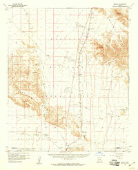
 1957 Redington1958 Print · USGSThe San Pedro River valley in the late fifties shows a landscape shaped by remote ranching and desert homesteads. Genealogists and historians can trace family-named sites like Bingham Ranch, the Cascabel School, and Soza Ranch.3 unique versions available
 - 1957 Map of Cortaro, 1959 Print
 1957 Cortaro1959 Print · USGSThe Santa Cruz Valley in the late fifties shows a landscape of developing irrigation and cattle ranching between mountain ranges. Genealogists and historians can trace family-named properties like T-Bench-Bar Ranch, local mining at Gila Monster Mine, and early school sites such as Laguna School.2 unique versions available
 - 1957 Map of Tucson North, 1959 Print
 1957 Tucson North1959 Print · USGSTucson is seen during its post-war suburban surge into the desert foothills before the reach of the modern metropolis. Genealogists and historians can trace the footprint of early schools like Prince Sch, the Rilvito Park and Race Track, and the Pontatoc Mine.4 unique versions available
 - 1957 Map of Mount Lemmon, 1959 Print
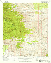
 1957 Mount Lemmon1959 Print · USGSGreater Tucson and the high Santa Catalina peaks are captured in the late fifties as the city’s northern suburbs began to meet the desert foothills. Researchers can trace the mid-century footprint of the University of Arizona Farm, the historic Steam Pump Ranch, and mountain retreats like Summerhaven.3 unique versions available
 - 1958 Map of Ajo
 1958 Ajo1958 Print · USGSThe high desert of Pima and Yuma Counties during the late fifties shows a landscape of remote copper mines and military flight paths. Researchers can trace the Southern Pacific Railroad through Gila Bend and find heritage sites like O'Neills Grave or the Christmas Gift Mine.2 unique versions available
 - 1958 Map of Nogales
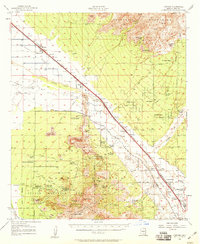
 1958 Nogales1958 Print · USGSSouthern Arizona in the late fifties was a landscape of international borders and high-desert outposts, dominated by the Huachuca Mountains and the Papago Indian Reservation. Local historians can trace old mining camps like Ruby and Greaterville or locate historic military grounds at the Fort Huachuca Military Reservation.
 - 1958 Map of Tucson
 1958 Tucson1958 Print · USGSSouthern Arizona in the late fifties reveals a landscape of desert agriculture and rising military aviation. Trace the rail lines of the Southern Pacific or locate the historic San Xavier Del Bac Mission and the Casa Grande Natl Mon.
 - 1958 Map of Kaka, 1959 Print
 1958 Kaka1959 Print · USGSThe Papago Indian Reservation and the rugged Sand Tank Mountains are captured in the late fifties, showing the remote settlement of Kaka. Researchers can locate the village Cemetery, old desert water sources like Moi Vaya Spring Well, and isolated Jeep Trails.2 unique versions available
 - 1958 Map of Midway, 1959 Print
 1958 Midway1959 Print · USGSThe desert landscape of Maricopa and Pima counties is captured here in the late 1950s, centered on the Tucson Cornelia and Gila Bend rail line. Genealogists and researchers can trace remote desert water sources like Well (that Johnny dug) and Slovan Well.3 unique versions available
 - 1958 Map of Happy Valley, 1959 Print
 1958 Happy Valley1959 Print · USGSSoutheast Arizona ranching culture and river life are captured here in the late fifties, from the San Pedro River valley to the high Rincon Mountains. Genealogists and historians can trace legacy holdings like the Allen Ranch and Martinez Ranch or the early layout of Pomerene.2 unique versions available
Showing maps 1-25 of 41
Top cities of Pima County
- Tucson historical maps
- Marana historical maps
- Oro Valley historical maps
- Sahuarita historical maps
- Vail historical maps
- Picture Rocks historical maps
See more
Frequently asked questions
- What are the different types of historical maps available for Pima County?
- What is the oldest map of Pima County?
- Where can I purchase historical maps of Pima County for my home or office?
- Where can I download high-res historical maps of Pima County?
- Are there historical topographic maps available for Pima County?
- Is there historical aerial imagery available for Pima County?
- Where are historical maps of Pima County sourced from?