1950s Maps of Washington, District of Columbia
Explore 10 historic maps of Washington from the 1950s. These maps offer a rare glimpse into what life looked like during the 1950s — showing old roads, neighborhoods, homes, and landmarks that have changed or disappeared over time.
Whether you're researching your family's past, planning a metal detecting trip, or studying how Washington's landscape evolved across the 1950s, these high-resolution maps are a powerful tool for exploring the history of this region.
- Focus on a specific era: All maps on this page are from the 1950s, giving you a focused view of this time period.
- See what’s changed: Compare century-old streets, trails, and buildings to today's modern landscape using overlays and satellite layers.
- Research with precision: Use these maps for genealogy, historical research, land use analysis, or educational projects.
- View, download, or print: Maps are fully viewable online in high resolution, and can be downloaded or printed for your own records.
Start exploring Washington's history through authentic maps from the 1950s. This is your window into the past.
Washington, DC maps
(10)- 1951 Map of Washington East
 1951 Washington East1951 Print · USGSThe Maryland and District of Columbia borderlands are caught in a period of intense post-war development. Local historians can trace the foundations of the University of Maryland, find the Franciscan Monastery, and locate vanished landmarks like Riggs Mill.
 - 1951 Map of Washington West
 1951 Washington West1951 Print · USGSWashington D.C. and its Maryland and Virginia suburbs appear here in the early fifties, just as the metropolitan area was beginning its massive post-war growth. Researchers can locate vanished streetscapes and institutional landmarks like the U S Soldiers Home, Glenwood Cem, and the historic Washington Cathedral.
 - 1951 Map of Alexandria
 1951 Alexandria1951 Print · USGSGreater Alexandria and Arlington are shown here in the early fifties during a period of massive suburban and military expansion. Researchers can trace the mid-century footprints of the Pentagon Building, the extensive rail lines of Potomac Yard, and local landmarks like Beacon Field.
 - 1951 Map of Anacostia
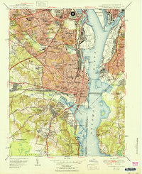
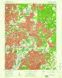
 1951 Anacostia1951 Print · USGSPrince George's County and Southeast D.C. are seen here during their mid-century expansion, blending federal nerve centers with emerging suburban neighborhoods. Genealogists and local historians can trace family roots through the numerous legacy Hebrew Cems, St Johns Ch, and the grounds of St Elizabeths Hospital.
 - 1956 Map of Anacostia
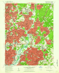
 1956 Anacostia1956 Print · USGSSoutheast Washington and Prince George's County are captured during a period of massive mid-century suburban and federal expansion. Genealogists and historians can trace the development of Fairfax Village, locate the Rosecroft Raceway, and find family sites at Cedar Hill Cem.2 unique versions available
 - 1956 Map of Alexandria, 1958 Print
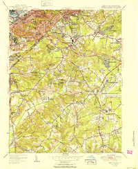
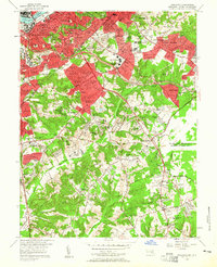
 1956 Alexandria1958 Print · USGSNorthern Virginia and D.C. are captured here in the mid-fifties during a period of rapid suburban and military growth. Genealogists and historians can trace family roots through neighborhood schools like Hoffman Boston High Sch or locate ancestors at Ivy Hill Cem and Alexandria National Cem.
 - 1956 Map of Washington West, 1958 Print
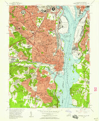
 1956 Washington West1958 Print · USGSMid-century Washington and its Maryland and Virginia suburbs appear here during a transformative era of growth. Genealogists and historians can trace neighborhood development and find landmarks like Arlington National Cemetery, the U S Capitol, and Georgetown University.
 - 1956 Map of Washington East, 1959 Print
 1956 Washington East1959 Print · USGSThe northern reaches of the capital and its Maryland suburbs come into focus during the mid-fifties, showing a landscape defined by institutional campuses and rail lines. Genealogists and historians can trace significant burial grounds like Mt Olivet Cemetery or locate historic landmarks such as Bird Stadium and the National Training School for Boys.
 - 1957 Map of Washington East, 1962 Print
 1957 Washington East1962 Print · USGSThe eastern edges of the District and Maryland's inner suburbs are captured here at the height of post-war growth. Researchers can trace the mid-century layout of local landmarks like the National Arboretum, the College Park Airport, and Mt Olivet Cemetery.
 - 1957 Map of Washington, 1966 Print
 1957 Washington1966 Print · USGSThe mid-Atlantic region during the mid-fifties and early sixties reveals a landscape of growing suburbs and vital military outposts. Researchers can trace historic river towns and shorelines from Alexandria to the Hooper Islands and St Clements Island.5 unique versions available
End of results
Showing maps 1-10 of 10
Top cities near Washington
- Arlington historical maps
- Alexandria historical maps
- Silver Spring historical maps
- Gaithersburg historical maps
- Bethesda historical maps
- Rockville historical maps
See more
Top neighborhoods of Washington
- Cleveland Park historical maps
- Foggy Bottom historical maps
- Anacostia historical maps
- Langston historical maps
- Fort Totten historical maps
- Dupont Circle historical maps
See more
Frequently asked questions
- What are the different types of historical maps available for Washington?
- What is the oldest map of Washington?
- Where can I purchase historical maps of Washington for my home or office?
- Where can I download high-res historical maps of Washington?
- Are there historical topographic maps available for Washington?
- Is there historical aerial imagery available for Washington?
- Where are historical maps of Washington sourced from?