1960s Maps of Logan County, Kansas
Explore 10 historic maps of Logan County from the 1960s. These maps offer a rare glimpse into what life looked like during the 1960s — showing old roads, neighborhoods, homes, and landmarks that have changed or disappeared over time.
Whether you're researching your family's past, planning a metal detecting trip, or studying how Logan County's landscape evolved across the 1960s, these high-resolution maps are a powerful tool for exploring the history of this region.
- Focus on a specific era: All maps on this page are from the 1960s, giving you a focused view of this time period.
- See what’s changed: Compare century-old streets, trails, and buildings to today's modern landscape using overlays and satellite layers.
- Research with precision: Use these maps for genealogy, historical research, land use analysis, or educational projects.
- View, download, or print: Maps are fully viewable online in high resolution, and can be downloaded or printed for your own records.
Start exploring Logan County's history through authentic maps from the 1960s. This is your window into the past.
Logan County, KS maps
(10)- 1968 Map of Russell Springs 3 NW, 1969 Print
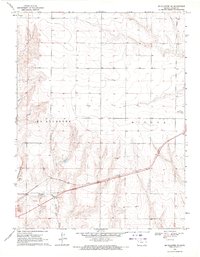
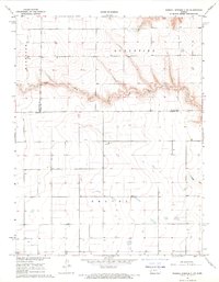 1968 Russell Springs 3 NW1969 Print · USGSWestern Kansas rangeland at the end of the 1960s is preserved here, showing the sparse infrastructure of the High Plains. Genealogists and historians can trace property boundaries across Harrison and Augustine or follow the course of Chalk Creek.2 unique versions available
 - 1968 Map of Russell Springs 3 NE, 1970 Print
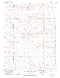
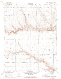 1968 Russell Springs 3 NE1970 Print · USGSHigh plains ranching and farming define this western Kansas landscape in the late sixties. Researchers can trace rural life through the Beulah Cem, High Plains Sch, and the isolated Church of the Nazarene.2 unique versions available
 - 1969 Map of Mc Allaster NW, 1971 Print
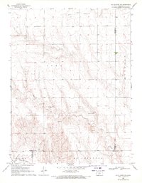 1969 Mc Allaster NW1971 Print · USGSThe High Plains of western Kansas are captured here in the late sixties at the convergence of four counties. Genealogists and local researchers can trace the drainages of the South Fork Solomon River and Sand Creek near features like the spillway.
 - 1969 Map of Russell Springs 2 NW, 1971 Print
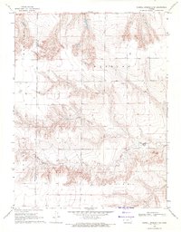
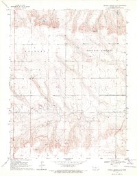
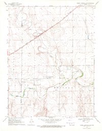 1969 Russell Springs 2 NW1971 Print · USGSLogan County during the late sixties reveals a landscape shaped by historical westward travel and the transition to rail. Trace the legendary Butterfield Overland Trail past several Historical Markers along the Smoky Hill River.2 unique versions available
 - 1969 Map of Mc Allaster SE, 1971 Print
 1969 Mc Allaster SE1971 Print · USGSWestern Kansas rangeland and the river breaks are captured in the late sixties as the local economy balanced rail transport and ranching. Trace the path of the Union Pacific near the North Fork Smoky Hill River and locate landmarks like the Lowe Landing Strip.
 - 1969 Map of Russell Springs 2 SW, 1971 Print
 1969 Russell Springs 2 SW1971 Print · USGSLogan and Wallace counties in the late sixties reveal a landscape defined by ranching life and intricate prairie drainage. Researchers can trace the intersection of early townships and locate landmarks like Little Eagle Ch and the prominent Twin Butte.2 unique versions available
 - 1969 Map of Russell Springs 2 NE, 1971 Print
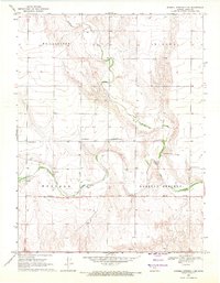 1969 Russell Springs 2 NE1971 Print · USGSLogan County prairie land is captured here in the late sixties, highlighting the path of the legendary Butterfield Overland Trail. Local historians can trace the old trail past several Historical Markers and follow the winding Smoky Hill River.2 unique versions available
 - 1969 Map of Mc Allaster NE, 1971 Print
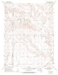
 1969 Mc Allaster NE1971 Print · USGSThe High Plains of Western Kansas are captured in the late sixties at the intersection of the Kingery and Winona townships. Researchers can trace the rural community at Brownville, locate the Brownville Cem, and see the early Landing Strip near the county line.
 - 1969 Map of Russell Springs 2 SE, 1971 Print
 1969 Russell Springs 2 SE1971 Print · USGSLogan County ranching and range land are captured here in the late sixties, showcasing the remote geography of western Kansas. Genealogists and historians can locate water sources like Nickel Mine Spring and industrial sites including a Gravel Pit and Quarry along Twin Butte Creek.2 unique versions available
 - 1969 Map of Mc Allaster, 1971 Print
 1969 Mc Allaster1971 Print · USGSThe High Plains of Logan County come to life in the late sixties, centered on the railroad siding of McAllaster. Researchers can trace the Union Pacific rail corridor and follow the winding North Fork Smoky Hill River past local Springs and a Marl Pit.2 unique versions available
End of results
Showing maps 1-10 of 10
Top cities of Logan County
- Oakley historical maps
- Winona historical maps
- Monument historical maps
- McAllaster historical maps
- Russell Springs historical maps
- Elkader historical maps
Frequently asked questions
- What are the different types of historical maps available for Logan County?
- What is the oldest map of Logan County?
- Where can I purchase historical maps of Logan County for my home or office?
- Where can I download high-res historical maps of Logan County?
- Are there historical topographic maps available for Logan County?
- Is there historical aerial imagery available for Logan County?
- Where are historical maps of Logan County sourced from?